Venus geodata
Venus (Texas) is a populated place; located in United States in America/Chicago (GMT-5) time zone. With population of 3,297 people, there are 9156 cities with bigger population in this country. Compared to other cities in United States, 87.4% of cities are located further ↑North; 76% of cities are located further →East and 52.2% of cities have lower elevation than Venus. Note1


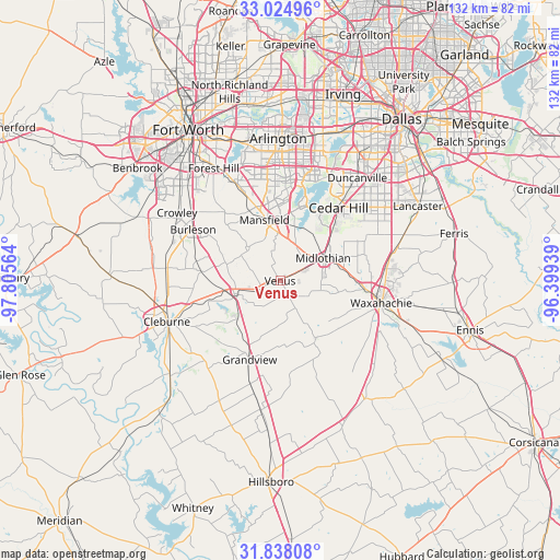
Venus GPS coordinates[2]
32° 26' 0.492" North, 97° 6' 9.036" West
| Map corner | latitude | longitude |
|---|---|---|
| Upper-left | 33.02496°, | -97.80564° |
| Center: | 32.43347°, | -97.10251° |
| Lower-right: | 31.83808°, | -96.39939° |
| Map W x H: | 132×132 km | = 82×82mi |
| max Lat: | 71.29058° ⇑87.4% North |
| Venus: | 32.43347° |
| min Lat: | ⇓12.6% South 19.06759° |
| min Long | Venus | max Long |
| -171.73463° | -97.10251° | -66.98998° |
| W 24%⇐ | ⇒76% E |
Elevation
Elevation of Venus is 207 m = 679 ft, and this is 87.8 m = 288 ft below average elevation for this country.
| Max E: |
3189 m = 10463 ft | 47.8% |
| Avg. | 294.8 m = 967 ft | |
| Venus | 207 m = 679 ft | |
Min E: |
-60 m = -197 ft | 52.2% |
See also: United States elevation on elevation.city.
Geographical zone
Venus is located in North temperate zone (between Tropic of Cancer and the Arctic Circle). Distance of this Northern Tropic circle is 1000.3 km =621.6 mi to South.| Distance of | km | miles | from Venus |
|---|---|---|---|
| North Pole | 6400.8 | 3977.3 | to North |
| Arctic Circle | 3794.9 | 2358 | to North |
| Tropic Cancer | 1000.3 | 621.6 | to South |
| Equator | 3606.3 | 2240.9 | to South |


Nearby cities:
15 places around Venus: (largest is in red/bold)
• Alvarado
10.7 km =6.6 mi,  253°
253°
• Burleson
23.8 km =14.8 mi,  300°
300°
• Cedar Hill
22 km =13.7 mi,  38°
38°
• Glenn Heights
26.4 km =16.4 mi,  60°
60°
• Grandview
19.5 km =12.1 mi,  201°
201°
• Joshua
27 km =16.8 mi,  276°
276°
• Keene
21.2 km =13.2 mi,  258°
258°
• Kennedale
26.4 km =16.4 mi,  334°
334°
• Mansfield
14.9 km =9.3 mi,  345°
345°
• Maypearl
15.9 km =9.9 mi,  147°
147°
• Midlothian
11.5 km =7.1 mi, 61°
• Oak Leaf
25.2 km =15.7 mi,  67°
67°
• Ovilla
22.8 km =14.2 mi, 62°
• Rendon
20.5 km =12.7 mi,  320°
320°
• Waxahachie
24.4 km =15.2 mi,  102°
102°
Sources, notices
• [Note1] Compared only with cities in United States existing in our database
• [Src1] Map data: © OpenStreetMap contributors (CC-BY-SA)
• [Src2] Other city data from geonames.org with taken over terms of usage.
• [Src3] Geographical zone / Annual Mean Temperature by Robert A. Rohde @ Wikipedia
