Mathis geodata
Mathis (Texas) is a populated place; located in United States in America/Chicago (GMT-5) time zone. With population of 5,037 people, there are 7136 cities with bigger population in this country. Compared to other cities in United States, 96.5% of cities are located further ↑North; 78.1% of cities are located further →East and 78.6% of cities have higher elevation than Mathis. Note1


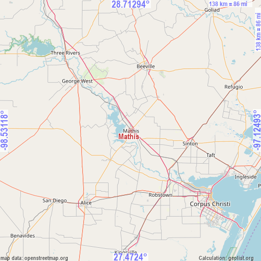
Mathis GPS coordinates[2]
28° 5' 40.056" North, 97° 49' 40.98" West
| Map corner | latitude | longitude |
|---|---|---|
| Upper-left | 28.71294°, | -98.53118° |
| Center: | 28.09446°, | -97.82805° |
| Lower-right: | 27.4724°, | -97.12493° |
| Map W x H: | 137.9×137.9 km | = 85.7×85.7mi |
| max Lat: | 71.29058° ⇑96.5% North |
| Mathis: | 28.09446° |
| min Lat: | ⇓3.5% South 19.06759° |
| min Long | Mathis | max Long |
| -171.73463° | -97.82805° | -66.98998° |
| W 21.9%⇐ | ⇒78.1% E |
Elevation
Elevation of Mathis is 53 m = 174 ft, and this is 241.8 m = 793 ft below average elevation for this country.
| Max E: |
3189 m = 10463 ft | 78.6% |
| Avg. | 294.8 m = 967 ft | |
| Mathis | 53 m = 174 ft | |
Min E: |
-60 m = -197 ft | 21.4% |
See also: United States elevation on elevation.city.
Geographical zone
Mathis is located in North temperate zone (between Tropic of Cancer and the Arctic Circle). Distance of this Northern Tropic circle is 517.9 km =321.8 mi to South.| Distance of | km | miles | from Mathis |
|---|---|---|---|
| North Pole | 6883.3 | 4277.1 | to North |
| Arctic Circle | 4277.4 | 2657.9 | to North |
| Tropic Cancer | 517.9 | 321.8 | to South |
| Equator | 3123.8 | 1941 | to South |


Nearby cities:
15 places around Mathis: (largest is in red/bold)
• Agua Dulce
35.7 km =22.2 mi,  192°
192°
• Banquete
32.2 km =20 mi,  174°
174°
• Beeville
34.9 km =21.7 mi,  12°
12°
• Blue Berry Hill
33 km =20.5 mi, 7°
• George West
38.8 km =24.1 mi,  313°
313°
• Lake City
5.9 km =3.7 mi,  253°
253°
• Lakeshore Gardens-Hidden Acres
4.7 km =2.9 mi,  315°
315°
• North San Pedro
35.4 km =22 mi,  156°
156°
• Odem
29 km =18 mi,  123°
123°
• Orange Grove
18.7 km =11.6 mi,  214°
214°
• Robstown
37.3 km =23.2 mi, 155°
• Saint Paul
26.7 km =16.6 mi,  88°
88°
• Sinton
31.9 km =19.8 mi,  101°
101°
• Skidmore
22.6 km =14 mi,  38°
38°
• Spring Gardens
37.9 km =23.5 mi, 166°
Sources, notices
• [Note1] Compared only with cities in United States existing in our database
• [Src1] Map data: © OpenStreetMap contributors (CC-BY-SA)
• [Src2] Other city data from geonames.org with taken over terms of usage.
• [Src3] Geographical zone / Annual Mean Temperature by Robert A. Rohde @ Wikipedia
