Point geodata
Point (Texas) is a populated place; located in United States in America/Chicago (GMT-5) time zone. With population of 834 people, there are 17494 cities with bigger population in this country. Compared to other cities in United States, 85.4% of cities are located further ↑North; 73.2% of cities are located further →East and 58.4% of cities have higher elevation than Point. Note1


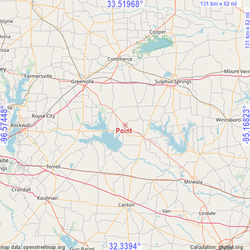
Point GPS coordinates[2]
32° 55' 53.436" North, 95° 52' 16.86" West
| Map corner | latitude | longitude |
|---|---|---|
| Upper-left | 33.51968°, | -96.57448° |
| Center: | 32.93151°, | -95.87135° |
| Lower-right: | 32.3394°, | -95.16823° |
| Map W x H: | 131.2×131.2 km | = 81.5×81.5mi |
| max Lat: | 71.29058° ⇑85.4% North |
| Point: | 32.93151° |
| min Lat: | ⇓14.6% South 19.06759° |
| min Long | Point | max Long |
| -171.73463° | -95.87135° | -66.98998° |
| W 26.8%⇐ | ⇒73.2% E |
Elevation
Elevation of Point is 163 m = 535 ft, and this is 131.8 m = 432 ft below average elevation for this country.
| Max E: |
3189 m = 10463 ft | 58.4% |
| Avg. | 294.8 m = 967 ft | |
| Point | 163 m = 535 ft | |
Min E: |
-60 m = -197 ft | 41.6% |
See also: United States elevation on elevation.city.
Geographical zone
Point is located in North temperate zone (between Tropic of Cancer and the Arctic Circle). Distance of this Northern Tropic circle is 1055.7 km =656 mi to South.| Distance of | km | miles | from Point |
|---|---|---|---|
| North Pole | 6345.4 | 3942.8 | to North |
| Arctic Circle | 3739.5 | 2323.6 | to North |
| Tropic Cancer | 1055.7 | 656 | to South |
| Equator | 3661.6 | 2275.2 | to South |


Nearby cities:
15 places around Point: (largest is in red/bold)
• Alba
27 km =16.8 mi,  124°
124°
• Campbell
25.2 km =15.7 mi,  342°
342°
• Commerce
35.2 km =21.9 mi,  355°
355°
• Cumby
23.1 km =14.4 mi,  7°
7°
• East Tawakoni
7.5 km =4.7 mi,  225°
225°
• Edgewood
26 km =16.2 mi,  182°
182°
• Emory
11.7 km =7.3 mi, 122°
• Grand Saline
32.4 km =20.1 mi,  152°
152°
• Greenville
32.1 km =19.9 mi,  315°
315°
• Gunter
23.6 km =14.7 mi,  107°
107°
• Lone Oak
9.7 km =6 mi, 318°
• Quinlan
24.8 km =15.4 mi,  264°
264°
• Sulphur Springs
34.1 km =21.2 mi,  47°
47°
• West Tawakoni
15.3 km =9.5 mi,  254°
254°
• Wills Point
27.8 km =17.3 mi,  207°
207°
Sources, notices
• [Note1] Compared only with cities in United States existing in our database
• [Src1] Map data: © OpenStreetMap contributors (CC-BY-SA)
• [Src2] Other city data from geonames.org with taken over terms of usage.
• [Src3] Geographical zone / Annual Mean Temperature by Robert A. Rohde @ Wikipedia
