Quinlan geodata
Quinlan (Texas) is a populated place; located in United States in America/Chicago (GMT-5) time zone. With population of 1,439 people, there are 13926 cities with bigger population in this country. Compared to other cities in United States, 85.5% of cities are located further ↑North; 73.7% of cities are located further →East and 58.8% of cities have higher elevation than Quinlan. Note1


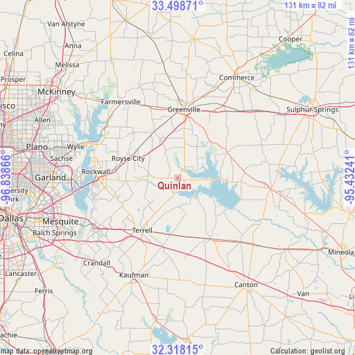
Quinlan GPS coordinates[2]
32° 54' 37.44" North, 96° 8' 7.908" West
| Map corner | latitude | longitude |
|---|---|---|
| Upper-left | 33.49871°, | -96.83866° |
| Center: | 32.9104°, | -96.13553° |
| Lower-right: | 32.31815°, | -95.43241° |
| Map W x H: | 131.3×131.3 km | = 81.6×81.6mi |
| max Lat: | 71.29058° ⇑85.5% North |
| Quinlan: | 32.9104° |
| min Lat: | ⇓14.5% South 19.06759° |
| min Long | Quinlan | max Long |
| -171.73463° | -96.13553° | -66.98998° |
| W 26.3%⇐ | ⇒73.7% E |
Elevation
Elevation of Quinlan is 161 m = 528 ft, and this is 133.8 m = 439 ft below average elevation for this country.
| Max E: |
3189 m = 10463 ft | 58.8% |
| Avg. | 294.8 m = 967 ft | |
| Quinlan | 161 m = 528 ft | |
Min E: |
-60 m = -197 ft | 41.2% |
See also: United States elevation on elevation.city.
Geographical zone
Quinlan is located in North temperate zone (between Tropic of Cancer and the Arctic Circle). Distance of this Northern Tropic circle is 1053.4 km =654.6 mi to South.| Distance of | km | miles | from Quinlan |
|---|---|---|---|
| North Pole | 6347.8 | 3944.3 | to North |
| Arctic Circle | 3741.9 | 2325.1 | to North |
| Tropic Cancer | 1053.4 | 654.6 | to South |
| Equator | 3659.3 | 2273.8 | to South |


Nearby cities:
15 places around Quinlan: (largest is in red/bold)
• Caddo Mills
19.3 km =12 mi,  333°
333°
• East Tawakoni
19.5 km =12.1 mi,  98°
98°
• Elmo
21.1 km =13.1 mi,  187°
187°
• Fate
23.2 km =14.4 mi,  278°
278°
• Greenville
25.5 km =15.8 mi,  5°
5°
• Josephine
23.2 km =14.4 mi,  316°
316°
• Lone Oak
20.6 km =12.8 mi,  62°
62°
• McLendon-Chisholm
24.1 km =15 mi,  251°
251°
• Nevada
26.6 km =16.5 mi,  303°
303°
• Point
24.8 km =15.4 mi,  84°
84°
• Rockwall
30.3 km =18.8 mi,  274°
274°
• Royse City
19.7 km =12.2 mi,  291°
291°
• Terrell
23.4 km =14.5 mi,  213°
213°
• West Tawakoni
10.1 km =6.3 mi, 100°
• Wills Point
25.3 km =15.7 mi,  151°
151°
Sources, notices
• [Note1] Compared only with cities in United States existing in our database
• [Src1] Map data: © OpenStreetMap contributors (CC-BY-SA)
• [Src2] Other city data from geonames.org with taken over terms of usage.
• [Src3] Geographical zone / Annual Mean Temperature by Robert A. Rohde @ Wikipedia
