Commerce geodata
Commerce (Texas) is a populated place; located in United States in America/Chicago (GMT-5) time zone. With population of 8,892 people, there are 4843 cities with bigger population in this country. Compared to other cities in United States, 84.1% of cities are located further ↑North; 73.2% of cities are located further →East and 56.8% of cities have higher elevation than Commerce. Note1


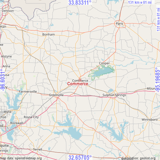
Commerce GPS coordinates[2]
33° 14' 49.416" North, 95° 53' 59.892" West
| Map corner | latitude | longitude |
|---|---|---|
| Upper-left | 33.83311°, | -96.6031° |
| Center: | 33.24706°, | -95.89997° |
| Lower-right: | 32.65705°, | -95.19685° |
| Map W x H: | 130.8×130.8 km | = 81.3×81.3mi |
| max Lat: | 71.29058° ⇑84.1% North |
| Commerce: | 33.24706° |
| min Lat: | ⇓15.9% South 19.06759° |
| min Long | Commerce | max Long |
| -171.73463° | -95.89997° | -66.98998° |
| W 26.8%⇐ | ⇒73.2% E |
Elevation
Elevation of Commerce is 172 m = 564 ft, and this is 122.8 m = 403 ft below average elevation for this country.
| Max E: |
3189 m = 10463 ft | 56.8% |
| Avg. | 294.8 m = 967 ft | |
| Commerce | 172 m = 564 ft | |
Min E: |
-60 m = -197 ft | 43.2% |
See also: United States elevation on elevation.city.
Geographical zone
Commerce is located in North temperate zone (between Tropic of Cancer and the Arctic Circle). Distance of this Northern Tropic circle is 1090.8 km =677.8 mi to South.| Distance of | km | miles | from Commerce |
|---|---|---|---|
| North Pole | 6310.3 | 3921 | to North |
| Arctic Circle | 3704.4 | 2301.8 | to North |
| Tropic Cancer | 1090.8 | 677.8 | to South |
| Equator | 3696.7 | 2297 | to South |


Nearby cities:
15 places around Commerce: (largest is in red/bold)
• Caddo Mills
36.6 km =22.7 mi,  236°
236°
• Campbell
12 km =7.5 mi,  203°
203°
• Celeste
27.9 km =17.3 mi,  280°
280°
• Cooper
24.2 km =15 mi,  54°
54°
• Cumby
13.4 km =8.3 mi,  155°
155°
• East Tawakoni
40.4 km =25.1 mi,  183°
183°
• Greenville
23 km =14.3 mi, 238°
• Honey Grove
37.4 km =23.2 mi,  358°
358°
• Ladonia
20.2 km =12.6 mi,  347°
347°
• Leonard
35.5 km =22.1 mi,  294°
294°
• Lone Oak
28.1 km =17.5 mi,  187°
187°
• Point
35.2 km =21.9 mi, 175°
• Roxton
37 km =23 mi,  25°
25°
• Sulphur Springs
30.3 km =18.8 mi,  113°
113°
• Wolfe City
20.9 km =13 mi,  311°
311°
Sources, notices
• [Note1] Compared only with cities in United States existing in our database
• [Src1] Map data: © OpenStreetMap contributors (CC-BY-SA)
• [Src2] Other city data from geonames.org with taken over terms of usage.
• [Src3] Geographical zone / Annual Mean Temperature by Robert A. Rohde @ Wikipedia
