San Benito geodata
San Benito (Texas) is a populated place; located in United States in America/Chicago (GMT-5) time zone. With population of 24,496 people, there are 2061 cities with bigger population in this country. Compared to other cities in United States, 98.7% of cities are located further ↑North; 77.5% of cities are located further →East and 90% of cities have higher elevation than San Benito. Note1


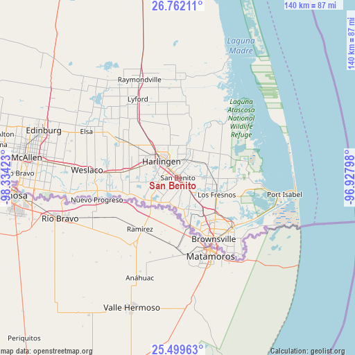
San Benito GPS coordinates[2]
26° 7' 57.288" North, 97° 37' 51.96" West
| Map corner | latitude | longitude |
|---|---|---|
| Upper-left | 26.76211°, | -98.33423° |
| Center: | 26.13258°, | -97.6311° |
| Lower-right: | 25.49963°, | -96.92798° |
| Map W x H: | 140.4×140.4 km | = 87.2×87.2mi |
| max Lat: | 71.29058° ⇑98.7% North |
| San Benito: | 26.13258° |
| min Lat: | ⇓1.3% South 19.06759° |
| min Long | San Benito | max Long |
| -171.73463° | -97.6311° | -66.98998° |
| W 22.5%⇐ | ⇒77.5% E |
Elevation
Elevation of San Benito is 16 m = 52 ft, and this is 278.8 m = 915 ft below average elevation for this country.
| Max E: |
3189 m = 10463 ft | 90% |
| Avg. | 294.8 m = 967 ft | |
| San Benito | 16 m = 52 ft | |
Min E: |
-60 m = -197 ft | 10% |
See also: United States elevation on elevation.city.
Geographical zone
San Benito is located in North temperate zone (between Tropic of Cancer and the Arctic Circle). Distance of this Northern Tropic circle is 299.8 km =186.3 mi to South.| Distance of | km | miles | from San Benito |
|---|---|---|---|
| North Pole | 7101.4 | 4412.6 | to North |
| Arctic Circle | 4495.5 | 2793.4 | to North |
| Tropic Cancer | 299.8 | 186.3 | to South |
| Equator | 2905.7 | 1805.5 | to South |


Nearby cities:
15 places around San Benito: (largest is in red/bold)
• Arroyo Colorado Estates Colonia
6.7 km =4.2 mi,  19°
19°
• Combes
16.5 km =10.3 mi,  321°
321°
• Encantada-Ranchito-El Calaboz
11 km =6.8 mi,  181°
181°
• Green Valley Farms
7.1 km =4.4 mi,  99°
99°
• Harlingen
9.2 km =5.7 mi,  314°
314°
• Indian Lake
13.7 km =8.5 mi,  110°
110°
• La Paloma
10.3 km =6.4 mi,  200°
200°
• Las Palmas II
13.1 km =8.1 mi, 305°
• Laureles
13.9 km =8.6 mi, 100°
• Los Indios
14.7 km =9.1 mi,  230°
230°
• Olmito
15.7 km =9.8 mi,  141°
141°
• Palm Valley
14.5 km =9 mi,  302°
302°
• Primera
16.4 km =10.2 mi, 309°
• Rancho Viejo
12.8 km =8 mi, 144°
• Rio Hondo
12.4 km =7.7 mi, 23°
Sources, notices
• [Note1] Compared only with cities in United States existing in our database
• [Src1] Map data: © OpenStreetMap contributors (CC-BY-SA)
• [Src2] Other city data from geonames.org with taken over terms of usage.
• [Src3] Geographical zone / Annual Mean Temperature by Robert A. Rohde @ Wikipedia
