San Felipe geodata
San Felipe (Texas) is a populated place; located in United States in America/Chicago (GMT-5) time zone. With population of 793 people, there are 17876 cities with bigger population in this country. Compared to other cities in United States, 93.9% of cities are located further ↑North; 73.6% of cities are located further →East and 79% of cities have higher elevation than San Felipe. Note1


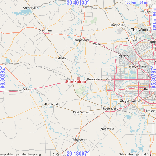
San Felipe GPS coordinates[2]
29° 47' 34.836" North, 96° 6' 2.844" West
| Map corner | latitude | longitude |
|---|---|---|
| Upper-left | 30.40133°, | -96.80392° |
| Center: | 29.79301°, | -96.10079° |
| Lower-right: | 29.18097°, | -95.39767° |
| Map W x H: | 135.7×135.7 km | = 84.3×84.3mi |
| max Lat: | 71.29058° ⇑93.9% North |
| San Felipe: | 29.79301° |
| min Lat: | ⇓6.1% South 19.06759° |
| min Long | San Felipe | max Long |
| -171.73463° | -96.10079° | -66.98998° |
| W 26.4%⇐ | ⇒73.6% E |
Elevation
Elevation of San Felipe is 51 m = 167 ft, and this is 243.8 m = 800 ft below average elevation for this country.
| Max E: |
3189 m = 10463 ft | 79% |
| Avg. | 294.8 m = 967 ft | |
| San Felipe | 51 m = 167 ft | |
Min E: |
-60 m = -197 ft | 21% |
See also: United States elevation on elevation.city.
Geographical zone
San Felipe is located in North temperate zone (between Tropic of Cancer and the Arctic Circle). Distance of this Northern Tropic circle is 706.8 km =439.2 mi to South.| Distance of | km | miles | from San Felipe |
|---|---|---|---|
| North Pole | 6694.4 | 4159.7 | to North |
| Arctic Circle | 4088.5 | 2540.5 | to North |
| Tropic Cancer | 706.8 | 439.2 | to South |
| Equator | 3312.7 | 2058.4 | to South |


Nearby cities:
15 places around San Felipe: (largest is in red/bold)
• Bellville
23.1 km =14.4 mi,  319°
319°
• Brookshire
14.5 km =9 mi,  93°
93°
• Cinco Ranch
33.6 km =20.9 mi,  100°
100°
• Eagle Lake
31.9 km =19.8 mi,  224°
224°
• East Bernard
29.3 km =18.2 mi,  174°
174°
• Fulshear
22.5 km =14 mi,  120°
120°
• Hempstead
33.9 km =21.1 mi,  3°
3°
• Katy
26.7 km =16.6 mi, 91°
• Pattison
10.8 km =6.7 mi,  70°
70°
• Pine Island
30.1 km =18.7 mi,  11°
11°
• Sealy
5.6 km =3.5 mi,  255°
255°
• Simonton
17.4 km =10.8 mi,  136°
136°
• Waller
33.8 km =21 mi,  29°
29°
• Wallis
18.3 km =11.4 mi, 169°
• Weston Lakes
20.1 km =12.5 mi,  127°
127°
Sources, notices
• [Note1] Compared only with cities in United States existing in our database
• [Src1] Map data: © OpenStreetMap contributors (CC-BY-SA)
• [Src2] Other city data from geonames.org with taken over terms of usage.
• [Src3] Geographical zone / Annual Mean Temperature by Robert A. Rohde @ Wikipedia
