Stephenville geodata
Stephenville (Texas) is a seat of a second-order administrative division; located in United States in America/Chicago (GMT-5) time zone. With population of 20,120 people, there are 2501 cities with bigger population in this country. Compared to other cities in United States, 88% of cities are located further ↑North; 78.9% of cities are located further →East and 83.2% of cities have lower elevation than Stephenville. Note1


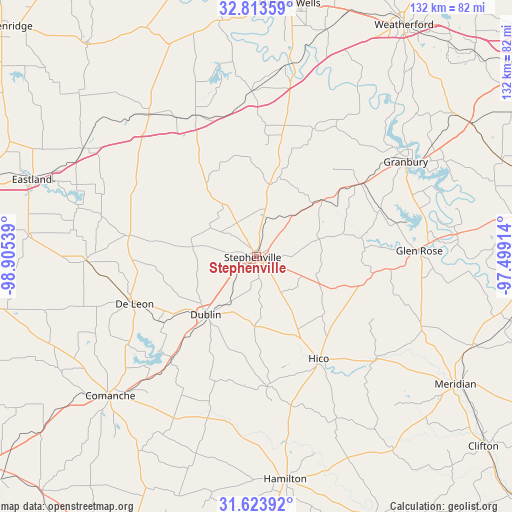
Stephenville GPS coordinates[2]
32° 13' 14.52" North, 98° 12' 8.136" West
| Map corner | latitude | longitude |
|---|---|---|
| Upper-left | 32.81359°, | -98.90539° |
| Center: | 32.2207°, | -98.20226° |
| Lower-right: | 31.62392°, | -97.49914° |
| Map W x H: | 132.3×132.3 km | = 82.2×82.2mi |
| max Lat: | 71.29058° ⇑88% North |
| Stephenville: | 32.2207° |
| min Lat: | ⇓12% South 19.06759° |
| min Long | Stephenville | max Long |
| -171.73463° | -98.20226° | -66.98998° |
| W 21.1%⇐ | ⇒78.9% E |
Elevation
Elevation of Stephenville is 393 m = 1289 ft, and this is 98.2 m = 322 ft above average elevation for this country.
| Max E: |
3189 m = 10463 ft | 16.8% |
| Stephenville | 393 m 1289 ft | |
| Avg. | 294.8 m = 967 ft | |
Min E: |
-60 m = -197 ft | 83.2% |
See also: United States elevation on elevation.city.
Geographical zone
Stephenville is located in North temperate zone (between Tropic of Cancer and the Arctic Circle). Distance of this Northern Tropic circle is 976.7 km =606.9 mi to South.| Distance of | km | miles | from Stephenville |
|---|---|---|---|
| North Pole | 6424.5 | 3992 | to North |
| Arctic Circle | 3818.6 | 2372.8 | to North |
| Tropic Cancer | 976.7 | 606.9 | to South |
| Equator | 3582.6 | 2226.1 | to South |


Nearby cities:
15 places around Stephenville: (largest is in red/bold)
• Comanche
52.2 km =32.4 mi,  226°
226°
• De Leon
33.7 km =20.9 mi,  248°
248°
• DeCordova
53 km =32.9 mi,  63°
63°
• Dublin
20 km =12.4 mi,  221°
221°
• Glen Rose
42.1 km =26.2 mi,  87°
87°
• Gorman
44.1 km =27.4 mi,  268°
268°
• Granbury
45.6 km =28.3 mi, 57°
• Hico
30.8 km =19.1 mi,  149°
149°
• Oak Trail Shores
45.6 km =28.3 mi,  49°
49°
• Pecan Plantation
51.9 km =32.2 mi,  72°
72°
• Ranger
52.7 km =32.7 mi,  301°
301°
• Strawn
46.1 km =28.6 mi,  322°
322°
• Tolar
32.4 km =20.1 mi, 54°
• Walnut Springs
46.3 km =28.8 mi,  113°
113°
• Western Lake
57.9 km =36 mi,  39°
39°
Sources, notices
• [Note1] Compared only with cities in United States existing in our database
• [Src1] Map data: © OpenStreetMap contributors (CC-BY-SA)
• [Src2] Other city data from geonames.org with taken over terms of usage.
• [Src3] Geographical zone / Annual Mean Temperature by Robert A. Rohde @ Wikipedia
