DeCordova geodata
DeCordova (Texas) is a populated place; located in United States in America/Chicago (GMT-5) time zone. With population of 2,855 people, there are 9899 cities with bigger population in this country. Compared to other cities in United States, 87.4% of cities are located further ↑North; 77.7% of cities are located further →East and 56.1% of cities have lower elevation than DeCordova. Note1


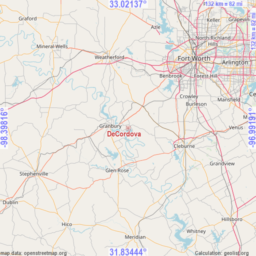
DeCordova GPS coordinates[2]
32° 25' 47.496" North, 97° 41' 42.108" West
| Map corner | latitude | longitude |
|---|---|---|
| Upper-left | 33.02137°, | -98.39816° |
| Center: | 32.42986°, | -97.69503° |
| Lower-right: | 31.83444°, | -96.99191° |
| Map W x H: | 132×132 km | = 82×82mi |
| max Lat: | 71.29058° ⇑87.4% North |
| DeCordova: | 32.42986° |
| min Lat: | ⇓12.6% South 19.06759° |
| min Long | DeCordova | max Long |
| -171.73463° | -97.69503° | -66.98998° |
| W 22.3%⇐ | ⇒77.7% E |
Elevation
Elevation of DeCordova is 223 m = 732 ft, and this is 71.8 m = 236 ft below average elevation for this country.
| Max E: |
3189 m = 10463 ft | 43.9% |
| Avg. | 294.8 m = 967 ft | |
| DeCordova | 223 m = 732 ft | |
Min E: |
-60 m = -197 ft | 56.1% |
See also: United States elevation on elevation.city.
Geographical zone
DeCordova is located in North temperate zone (between Tropic of Cancer and the Arctic Circle). Distance of this Northern Tropic circle is 999.9 km =621.3 mi to South.| Distance of | km | miles | from DeCordova |
|---|---|---|---|
| North Pole | 6401.2 | 3977.5 | to North |
| Arctic Circle | 3795.3 | 2358.3 | to North |
| Tropic Cancer | 999.9 | 621.3 | to South |
| Equator | 3605.9 | 2240.6 | to South |


Nearby cities:
15 places around DeCordova: (largest is in red/bold)
• Aledo
30.8 km =19.1 mi,  16°
16°
• Annetta
31.1 km =19.3 mi,  3°
3°
• Annetta North
32.2 km =20 mi, 3°
• Annetta South
26.7 km =16.6 mi,  6°
6°
• Benbrook
34.9 km =21.7 mi,  39°
39°
• Cleburne
30.4 km =18.9 mi,  107°
107°
• Cresson
13.5 km =8.4 mi,  32°
32°
• Glen Rose
22.4 km =13.9 mi,  194°
194°
• Godley
15.9 km =9.9 mi,  82°
82°
• Granbury
9.4 km =5.8 mi,  278°
278°
• Joshua
29 km =18 mi, 83°
• Oak Trail Shores
14.6 km =9.1 mi,  296°
296°
• Pecan Plantation
7.9 km =4.9 mi,  166°
166°
• Tolar
21.7 km =13.5 mi,  257°
257°
• Western Lake
24.1 km =15 mi,  333°
333°
Sources, notices
• [Note1] Compared only with cities in United States existing in our database
• [Src1] Map data: © OpenStreetMap contributors (CC-BY-SA)
• [Src2] Other city data from geonames.org with taken over terms of usage.
• [Src3] Geographical zone / Annual Mean Temperature by Robert A. Rohde @ Wikipedia
