Bull Run Mountain Estates geodata
Bull Run Mountain Estates (Virginia) is a populated place; located in United States in America/New_York (GMT-4) time zone. With population of 1,251 people, there are 14847 cities with bigger population in this country. Compared to other cities in United States, 55.8% of cities are located further ↑North; 78.5% of cities are located further ←West and 57.5% of cities have higher elevation than Bull Run Mountain Estates. Note1
Current local time in Bull Run Mountain Estates:
05:21 AM, FridayDifference from your time zone: hours


Bull Run Mountain Estates GPS coordinates[2]
38° 54' 13.392" North, 77° 39' 41.976" West
| Map corner | latitude | longitude |
|---|---|---|
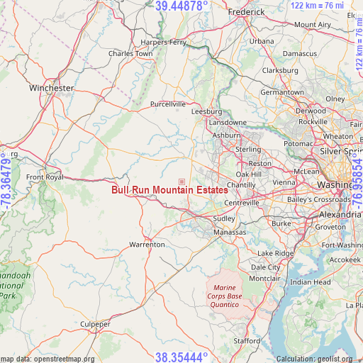
| Upper-left | 39.44878°, | -78.36479° |
| Center: | 38.90372°, | -77.66166° |
| Lower-right: | 38.35444°, | -76.95854° |
| Map W x H: | 121.7×121.7 km | = 75.6×75.6mi |
| max Lat: | 71.29058° ⇑55.8% North |
| Bull Run Mountain Estates: | 38.90372° |
| min Lat: | ⇓44.2% South 19.06759° |
| min Long | Bull Run Mounta | max Long |
| -171.73463° | -77.66166° | -66.98998° |
| W 78.5%⇐ | ⇒21.5% E |
Elevation
Elevation of Bull Run Mountain Estates is 168 m = 551 ft, and this is 126.8 m = 416 ft below average elevation for this country.
| Max E: |
3189 m = 10463 ft | 57.5% |
| Avg. | 294.8 m = 967 ft | |
| Bull Run Mountain Estates | 168 m = 551 ft | |
Min E: |
-60 m = -197 ft | 42.5% |
See also: United States elevation on elevation.city.
Geographical zone
Bull Run Mountain Estates is located in North temperate zone (between Tropic of Cancer and the Arctic Circle). Distance of this Northern Tropic circle is 1719.8 km =1068.6 mi to South.| Distance of | km | miles | from Bull Run Mountain Estates |
|---|---|---|---|
| North Pole | 5681.4 | 3530.3 | to North |
| Arctic Circle | 3075.5 | 1911 | to North |
| Tropic Cancer | 1719.8 | 1068.6 | to South |
| Equator | 4325.7 | 2687.9 | to South |


Nearby cities:
15 places around Bull Run Mountain Estates: (largest is in red/bold)
• Brambleton
13.8 km =8.6 mi,  50°
50°
• Broadlands
17.6 km =10.9 mi,  43°
43°
• Bull Run
18.1 km =11.2 mi,  137°
137°
• Chantilly
20 km =12.4 mi,  93°
93°
• Gainesville
12.7 km =7.9 mi,  160°
160°
• Haymarket
10.4 km =6.5 mi,  167°
167°
• Linton Hall
17.7 km =11 mi,  154°
154°
• Loch Lomond
20.6 km =12.8 mi,  129°
129°
• Loudoun Valley Estates
15.8 km =9.8 mi,  57°
57°
• Marshall
17.5 km =10.9 mi,  255°
255°
• Middleburg
9.6 km =6 mi,  318°
318°
• New Baltimore
16.2 km =10.1 mi,  200°
200°
• South Riding
13.8 km =8.6 mi,  82°
82°
• Sudley
18.8 km =11.7 mi, 130°
• West Gate
19.6 km =12.2 mi, 133°
Sources, notices
• [Note1] Compared only with cities in United States existing in our database
• [Src1] Map data: © OpenStreetMap contributors (CC-BY-SA)
• [Src2] Other city data from geonames.org with taken over terms of usage.
• [Src3] Geographical zone / Annual Mean Temperature by Robert A. Rohde @ Wikipedia
