Marshall geodata
Marshall (Virginia) is a populated place; located in United States in America/New_York (GMT-4) time zone. With population of 1,480 people, there are 13750 cities with bigger population in this country. Compared to other cities in United States, 56.1% of cities are located further ↑North; 78.1% of cities are located further ←West and 52.2% of cities have lower elevation than Marshall. Note1


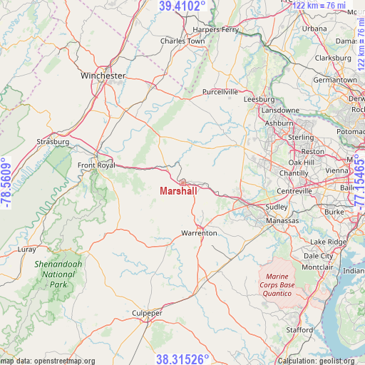
Marshall GPS coordinates[2]
38° 51' 53.424" North, 77° 51' 27.972" West
| Map corner | latitude | longitude |
|---|---|---|
| Upper-left | 39.4102°, | -78.5609° |
| Center: | 38.86484°, | -77.85777° |
| Lower-right: | 38.31526°, | -77.15465° |
| Map W x H: | 121.7×121.7 km | = 75.6×75.6mi |
| max Lat: | 71.29058° ⇑56.1% North |
| Marshall: | 38.86484° |
| min Lat: | ⇓43.9% South 19.06759° |
| min Long | Marshall | max Long |
| -171.73463° | -77.85777° | -66.98998° |
| W 78.1%⇐ | ⇒21.9% E |
Elevation
Elevation of Marshall is 207 m = 679 ft, and this is 87.8 m = 288 ft below average elevation for this country.
| Max E: |
3189 m = 10463 ft | 47.8% |
| Avg. | 294.8 m = 967 ft | |
| Marshall | 207 m = 679 ft | |
Min E: |
-60 m = -197 ft | 52.2% |
See also: United States elevation on elevation.city.
Geographical zone
Marshall is located in North temperate zone (between Tropic of Cancer and the Arctic Circle). Distance of this Northern Tropic circle is 1715.4 km =1065.9 mi to South.| Distance of | km | miles | from Marshall |
|---|---|---|---|
| North Pole | 5685.7 | 3532.9 | to North |
| Arctic Circle | 3079.8 | 1913.7 | to North |
| Tropic Cancer | 1715.4 | 1065.9 | to South |
| Equator | 4321.4 | 2685.2 | to South |


Nearby cities:
15 places around Marshall: (largest is in red/bold)
• Apple Mountain Lake
22.1 km =13.7 mi,  287°
287°
• Bull Run Mountain Estates
17.5 km =10.9 mi,  75°
75°
• Chester Gap
24 km =14.9 mi,  266°
266°
• Front Royal
29.7 km =18.5 mi,  281°
281°
• Gainesville
22.5 km =14 mi,  110°
110°
• Haymarket
20.1 km =12.5 mi, 107°
• Linton Hall
27.1 km =16.8 mi,  115°
115°
• Middleburg
15.7 km =9.8 mi,  42°
42°
• New Baltimore
15.6 km =9.7 mi,  134°
134°
• Opal
27.6 km =17.1 mi,  169°
169°
• Shenandoah Farms
22.9 km =14.2 mi,  304°
304°
• Shenandoah Retreat
30 km =18.6 mi,  358°
358°
• Shenandoah Shores
26.9 km =16.7 mi, 293°
• Skyland Estates
20.5 km =12.7 mi, 288°
• Warrenton
17.7 km =11 mi,  162°
162°
Sources, notices
• [Note1] Compared only with cities in United States existing in our database
• [Src1] Map data: © OpenStreetMap contributors (CC-BY-SA)
• [Src2] Other city data from geonames.org with taken over terms of usage.
• [Src3] Geographical zone / Annual Mean Temperature by Robert A. Rohde @ Wikipedia
