Chesterfield Court House geodata
Chesterfield Court House (Virginia) is a populated place; located in United States in America/New_York (GMT-4) time zone. With population of 3,808 people, there are 8447 cities with bigger population in this country. Compared to other cities in United States, 64.5% of cities are located further ↑North; 78.9% of cities are located further ←West and 76.7% of cities have higher elevation than Chesterfield Court House. Note1
Current local time in Chesterfield Court House:
02:48 PM, WednesdayDifference from your time zone: hours


Chesterfield Court House GPS coordinates[2]
37° 22' 37.524" North, 77° 30' 17.964" West
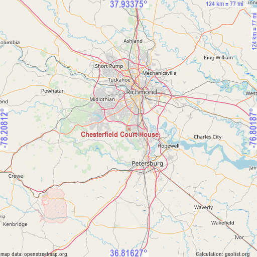
| Map corner | latitude | longitude |
|---|---|---|
| Upper-left | 37.93375°, | -78.20812° |
| Center: | 37.37709°, | -77.50499° |
| Lower-right: | 36.81627°, | -76.80187° |
| Map W x H: | 124.3×124.3 km | = 77.2×77.2mi |
| max Lat: | 71.29058° ⇑64.5% North |
| Chesterfield Court House: | 37.37709° |
| min Lat: | ⇓35.5% South 19.06759° |
| min Long | Chesterfield Co | max Long |
| -171.73463° | -77.50499° | -66.98998° |
| W 78.9%⇐ | ⇒21.1% E |
Elevation
Elevation of Chesterfield Court House is 62 m = 203 ft, and this is 232.8 m = 764 ft below average elevation for this country.
| Max E: |
3189 m = 10463 ft | 76.7% |
| Avg. | 294.8 m = 967 ft | |
| Chesterfield Court House | 62 m = 203 ft | |
Min E: |
-60 m = -197 ft | 23.3% |
See also: United States elevation on elevation.city.
Geographical zone
Chesterfield Court House is located in North temperate zone (between Tropic of Cancer and the Arctic Circle). Distance of this Northern Tropic circle is 1550 km =963.1 mi to South.| Distance of | km | miles | from Chesterfield Court House |
|---|---|---|---|
| North Pole | 5851.1 | 3635.7 | to North |
| Arctic Circle | 3245.2 | 2016.5 | to North |
| Tropic Cancer | 1550 | 963.1 | to South |
| Equator | 4155.9 | 2582.4 | to South |


Nearby cities:
15 places around Chesterfield Court House: (largest is in red/bold)
• Bellwood
7.8 km =4.8 mi,  50°
50°
• Bensley
9.5 km =5.9 mi,  35°
35°
• Bon Air
17.1 km =10.6 mi,  344°
344°
• Brandermill
14.2 km =8.8 mi,  295°
295°
• Chester
6 km =3.7 mi,  111°
111°
• Chesterfield
0.1 km =0.1 mi,  270°
270°
• Colonial Heights
14.9 km =9.3 mi,  144°
144°
• Enon
16.9 km =10.5 mi, 107°
• Ettrick
16.6 km =10.3 mi,  156°
156°
• Matoaca
16.5 km =10.3 mi,  171°
171°
• Meadowbrook
8.4 km =5.2 mi,  19°
19°
• Montrose
19.5 km =12.1 mi, 35°
• Petersburg
18.9 km =11.7 mi,  151°
151°
• Richmond
20 km =12.4 mi,  11°
11°
• Woodlake
16.2 km =10.1 mi,  287°
287°
Sources, notices
• [Note1] Compared only with cities in United States existing in our database
• [Src1] Map data: © OpenStreetMap contributors (CC-BY-SA)
• [Src2] Other city data from geonames.org with taken over terms of usage.
• [Src3] Geographical zone / Annual Mean Temperature by Robert A. Rohde @ Wikipedia
