Enon geodata
Enon (Virginia) is a populated place; located in United States in America/New_York (GMT-4) time zone. With population of 3,466 people, there are 8889 cities with bigger population in this country. Compared to other cities in United States, 64.7% of cities are located further ↑North; 79.4% of cities are located further ←West and 92.1% of cities have higher elevation than Enon. Note1


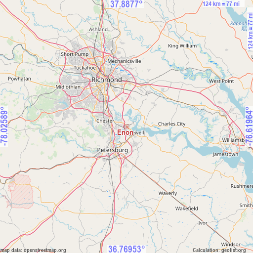
Enon GPS coordinates[2]
37° 19' 50.52" North, 77° 19' 21.936" West
| Map corner | latitude | longitude |
|---|---|---|
| Upper-left | 37.8877°, | -78.02589° |
| Center: | 37.3307°, | -77.32276° |
| Lower-right: | 36.76953°, | -76.61964° |
| Map W x H: | 124.3×124.3 km | = 77.2×77.2mi |
| max Lat: | 71.29058° ⇑64.7% North |
| Enon: | 37.3307° |
| min Lat: | ⇓35.3% South 19.06759° |
| min Long | Enon | max Long |
| -171.73463° | -77.32276° | -66.98998° |
| W 79.4%⇐ | ⇒20.6% E |
Elevation
Elevation of Enon is 12 m = 39 ft, and this is 282.8 m = 928 ft below average elevation for this country.
| Max E: |
3189 m = 10463 ft | 92.1% |
| Avg. | 294.8 m = 967 ft | |
| Enon | 12 m = 39 ft | |
Min E: |
-60 m = -197 ft | 7.9% |
See also: United States elevation on elevation.city.
Geographical zone
Enon is located in North temperate zone (between Tropic of Cancer and the Arctic Circle). Distance of this Northern Tropic circle is 1544.9 km =960 mi to South.| Distance of | km | miles | from Enon |
|---|---|---|---|
| North Pole | 5856.3 | 3638.9 | to North |
| Arctic Circle | 3250.4 | 2019.7 | to North |
| Tropic Cancer | 1544.9 | 960 | to South |
| Equator | 4150.8 | 2579.2 | to South |


Nearby cities:
15 places around Enon: (largest is in red/bold)
• Bellwood
14.3 km =8.9 mi,  314°
314°
• Bensley
16.7 km =10.4 mi,  320°
320°
• Chester
10.9 km =6.8 mi,  285°
285°
• Chesterfield
17 km =10.6 mi, 287°
• Chesterfield Court House
16.9 km =10.5 mi, 287°
• Colonial Heights
10.2 km =6.3 mi,  227°
227°
• Ettrick
13.8 km =8.6 mi,  223°
223°
• Fort Lee
9.4 km =5.8 mi,  186°
186°
• Fort Lee
18.4 km =11.4 mi,  356°
356°
• Hopewell
4.3 km =2.7 mi,  133°
133°
• Matoaca
17.7 km =11 mi, 230°
• Meadowbrook
18.7 km =11.6 mi, 314°
• Petersburg
13.4 km =8.3 mi,  211°
211°
• Prince George
12.6 km =7.8 mi,  165°
165°
• Sandston
21.4 km =13.3 mi,  1°
1°
Sources, notices
• [Note1] Compared only with cities in United States existing in our database
• [Src1] Map data: © OpenStreetMap contributors (CC-BY-SA)
• [Src2] Other city data from geonames.org with taken over terms of usage.
• [Src3] Geographical zone / Annual Mean Temperature by Robert A. Rohde @ Wikipedia
