Richmond geodata
Richmond (Virginia) is a seat of a first-order administrative division; located in United States in America/New_York (GMT-4) time zone. With population of 220,289 people, there are 109 cities with bigger population in this country. Compared to other cities in United States, 63.9% of cities are located further ↑North; 79% of cities are located further ←West and 75.6% of cities have higher elevation than Richmond. Note1


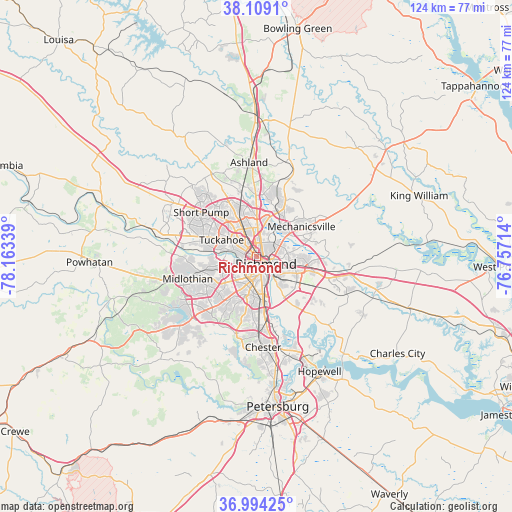
Richmond GPS coordinates[2]
37° 33' 13.536" North, 77° 27' 36.936" West
| Map corner | latitude | longitude |
|---|---|---|
| Upper-left | 38.1091°, | -78.16339° |
| Center: | 37.55376°, | -77.46026° |
| Lower-right: | 36.99425°, | -76.75714° |
| Map W x H: | 124×124 km | = 77.1×77.1mi |
| max Lat: | 71.29058° ⇑63.9% North |
| Richmond: | 37.55376° |
| min Lat: | ⇓36.1% South 19.06759° |
| min Long | Richmond | max Long |
| -171.73463° | -77.46026° | -66.98998° |
| W 79%⇐ | ⇒21% E |
Elevation
Elevation of Richmond is 68 m = 223 ft, and this is 226.8 m = 744 ft below average elevation for this country.
| Max E: |
3189 m = 10463 ft | 75.6% |
| Avg. | 294.8 m = 967 ft | |
| Richmond | 68 m = 223 ft | |
Min E: |
-60 m = -197 ft | 24.4% |
See also: Richmond elevation on elevation.city.
Geographical zone
Richmond is located in North temperate zone (between Tropic of Cancer and the Arctic Circle). Distance of this Northern Tropic circle is 1569.7 km =975.4 mi to South.| Distance of | km | miles | from Richmond |
|---|---|---|---|
| North Pole | 5831.5 | 3623.5 | to North |
| Arctic Circle | 3225.6 | 2004.3 | to North |
| Tropic Cancer | 1569.7 | 975.4 | to South |
| Equator | 4175.6 | 2594.6 | to South |


Nearby cities:
15 places around Richmond: (largest is in red/bold)
• Bensley
12 km =7.5 mi,  172°
172°
• Bon Air
9.2 km =5.7 mi,  249°
249°
• Chamberlayne
8.6 km =5.3 mi,  19°
19°
• Dumbarton
6.2 km =3.9 mi,  333°
333°
• East Highland Park
5.6 km =3.5 mi,  57°
57°
• Fort Lee
12.8 km =8 mi,  120°
120°
• Glen Allen
13.1 km =8.1 mi,  341°
341°
• Highland Springs
11.7 km =7.3 mi,  94°
94°
• Lakeside
6.2 km =3.9 mi,  346°
346°
• Laurel
10.8 km =6.7 mi, 336°
• Laurel Park
10.5 km =6.5 mi, 340°
• Meadowbrook
11.7 km =7.3 mi,  185°
185°
• Mechanicsville
9.8 km =6.1 mi,  51°
51°
• Montrose
8.1 km =5 mi, 116°
• Tuckahoe
9.4 km =5.8 mi,  295°
295°
Sources, notices
• [Note1] Compared only with cities in United States existing in our database
• [Src1] Map data: © OpenStreetMap contributors (CC-BY-SA)
• [Src2] Other city data from geonames.org with taken over terms of usage.
• [Src3] Geographical zone / Annual Mean Temperature by Robert A. Rohde @ Wikipedia
