Cloverdale geodata
Cloverdale (Virginia) is a populated place; located in United States in America/New_York (GMT-4) time zone. With population of 3,119 people, there are 9430 cities with bigger population in this country. Compared to other cities in United States, 64.6% of cities are located further ↑North; 73.7% of cities are located further ←West and 79% of cities have lower elevation than Cloverdale. Note1


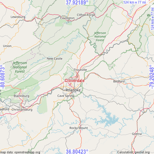
Cloverdale GPS coordinates[2]
37° 21' 54.504" North, 79° 54' 20.16" West
| Map corner | latitude | longitude |
|---|---|---|
| Upper-left | 37.92189°, | -80.60873° |
| Center: | 37.36514°, | -79.9056° |
| Lower-right: | 36.80423°, | -79.20248° |
| Map W x H: | 124.3×124.3 km | = 77.2×77.2mi |
| max Lat: | 71.29058° ⇑64.6% North |
| Cloverdale: | 37.36514° |
| min Lat: | ⇓35.4% South 19.06759° |
| min Long | Cloverdale | max Long |
| -171.73463° | -79.9056° | -66.98998° |
| W 73.7%⇐ | ⇒26.3% E |
Elevation
Elevation of Cloverdale is 344 m = 1129 ft, and this is 49.2 m = 161 ft above average elevation for this country.
| Max E: |
3189 m = 10463 ft | 21% |
| Cloverdale | 344 m 1129 ft | |
| Avg. | 294.8 m = 967 ft | |
Min E: |
-60 m = -197 ft | 79% |
See also: United States elevation on elevation.city.
Geographical zone
Cloverdale is located in North temperate zone (between Tropic of Cancer and the Arctic Circle). Distance of this Northern Tropic circle is 1548.7 km =962.3 mi to South.| Distance of | km | miles | from Cloverdale |
|---|---|---|---|
| North Pole | 5852.4 | 3636.5 | to North |
| Arctic Circle | 3246.6 | 2017.3 | to North |
| Tropic Cancer | 1548.7 | 962.3 | to South |
| Equator | 4154.6 | 2581.5 | to South |


Nearby cities:
15 places around Cloverdale: (largest is in red/bold)
• Blue Ridge
8.8 km =5.5 mi,  80°
80°
• Cave Spring
18 km =11.2 mi,  211°
211°
• Cedar Bluff
11.5 km =7.1 mi,  193°
193°
• Daleville
5 km =3.1 mi,  352°
352°
• Fincastle
15.1 km =9.4 mi,  9°
9°
• Glenvar
22.6 km =14 mi,  243°
243°
• Hollins
4.2 km =2.6 mi,  231°
231°
• Laymantown
4.2 km =2.6 mi,  89°
89°
• Montvale
15.6 km =9.7 mi, 82°
• Narrows
18.4 km =11.4 mi, 194°
• New Castle
23.5 km =14.6 mi,  309°
309°
• Roanoke
10.9 km =6.8 mi,  196°
196°
• Salem
15.4 km =9.6 mi, 238°
• Villa Heights
10.1 km =6.3 mi,  219°
219°
• Vinton
9.4 km =5.8 mi,  175°
175°
Sources, notices
• [Note1] Compared only with cities in United States existing in our database
• [Src1] Map data: © OpenStreetMap contributors (CC-BY-SA)
• [Src2] Other city data from geonames.org with taken over terms of usage.
• [Src3] Geographical zone / Annual Mean Temperature by Robert A. Rohde @ Wikipedia
