Roanoke geodata
Roanoke (Virginia) is a seat of a second-order administrative division; located in United States in America/New_York (GMT-4) time zone. With population of 99,897 people, there are 349 cities with bigger population in this country. Compared to other cities in United States, 65% of cities are located further ↑North; 73.5% of cities are located further ←West and 72% of cities have lower elevation than Roanoke. Note1


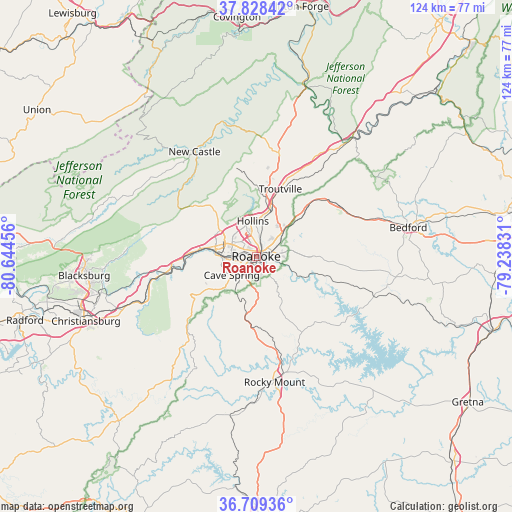
Roanoke GPS coordinates[2]
37° 16' 15.492" North, 79° 56' 29.148" West
| Map corner | latitude | longitude |
|---|---|---|
| Upper-left | 37.82842°, | -80.64456° |
| Center: | 37.27097°, | -79.94143° |
| Lower-right: | 36.70936°, | -79.23831° |
| Map W x H: | 124.4×124.4 km | = 77.3×77.3mi |
| max Lat: | 71.29058° ⇑65% North |
| Roanoke: | 37.27097° |
| min Lat: | ⇓35% South 19.06759° |
| min Long | Roanoke | max Long |
| -171.73463° | -79.94143° | -66.98998° |
| W 73.5%⇐ | ⇒26.5% E |
Elevation
Elevation of Roanoke is 296 m = 971 ft, and this is 1.2 m = 4 ft above average elevation for this country.
| Max E: |
3189 m = 10463 ft | 28% |
| Roanoke | 296 m 971 ft | |
| Avg. | 294.8 m = 967 ft | |
Min E: |
-60 m = -197 ft | 72% |
See also: Roanoke elevation on elevation.city.
Geographical zone
Roanoke is located in North temperate zone (between Tropic of Cancer and the Arctic Circle). Distance of this Northern Tropic circle is 1538.2 km =955.8 mi to South.| Distance of | km | miles | from Roanoke |
|---|---|---|---|
| North Pole | 5862.9 | 3643 | to North |
| Arctic Circle | 3257 | 2023.8 | to North |
| Tropic Cancer | 1538.2 | 955.8 | to South |
| Equator | 4144.1 | 2575 | to South |


Nearby cities:
15 places around Roanoke: (largest is in red/bold)
• Blue Ridge
16.9 km =10.5 mi,  44°
44°
• Cave Spring
7.9 km =4.9 mi,  232°
232°
• Cedar Bluff
0.9 km =0.6 mi,  144°
144°
• Cloverdale
10.9 km =6.8 mi,  16°
16°
• Daleville
15.7 km =9.8 mi,  9°
9°
• Elliston
26.5 km =16.5 mi,  256°
256°
• Fincastle
26 km =16.2 mi, 12°
• Glenvar
17 km =10.6 mi,  271°
271°
• Hollins
7.8 km =4.8 mi,  358°
358°
• Laymantown
12.9 km =8 mi, 35°
• Montvale
22.5 km =14 mi,  55°
55°
• Narrows
7.5 km =4.7 mi,  191°
191°
• Salem
10.3 km =6.4 mi,  284°
284°
• Villa Heights
4.2 km =2.6 mi,  310°
310°
• Vinton
4.1 km =2.5 mi,  74°
74°
Sources, notices
• [Note1] Compared only with cities in United States existing in our database
• [Src1] Map data: © OpenStreetMap contributors (CC-BY-SA)
• [Src2] Other city data from geonames.org with taken over terms of usage.
• [Src3] Geographical zone / Annual Mean Temperature by Robert A. Rohde @ Wikipedia
