Cave Spring geodata
Cave Spring (Virginia) is a populated place; located in United States in America/New_York (GMT-4) time zone. With population of 24,922 people, there are 2016 cities with bigger population in this country. Compared to other cities in United States, 65.2% of cities are located further ↑North; 73.2% of cities are located further ←West and 78.3% of cities have lower elevation than Cave Spring. Note1


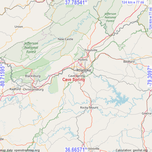
Cave Spring GPS coordinates[2]
37° 13' 39.504" North, 80° 0' 46.152" West
| Map corner | latitude | longitude |
|---|---|---|
| Upper-left | 37.78541°, | -80.71595° |
| Center: | 37.22764°, | -80.01282° |
| Lower-right: | 36.66571°, | -79.3097° |
| Map W x H: | 124.5×124.5 km | = 77.4×77.4mi |
| max Lat: | 71.29058° ⇑65.2% North |
| Cave Spring: | 37.22764° |
| min Lat: | ⇓34.8% South 19.06759° |
| min Long | Cave Spring | max Long |
| -171.73463° | -80.01282° | -66.98998° |
| W 73.2%⇐ | ⇒26.8% E |
Elevation
Elevation of Cave Spring is 338 m = 1109 ft, and this is 43.2 m = 142 ft above average elevation for this country.
| Max E: |
3189 m = 10463 ft | 21.7% |
| Cave Spring | 338 m 1109 ft | |
| Avg. | 294.8 m = 967 ft | |
Min E: |
-60 m = -197 ft | 78.3% |
See also: United States elevation on elevation.city.
Geographical zone
Cave Spring is located in North temperate zone (between Tropic of Cancer and the Arctic Circle). Distance of this Northern Tropic circle is 1533.4 km =952.8 mi to South.| Distance of | km | miles | from Cave Spring |
|---|---|---|---|
| North Pole | 5867.7 | 3646 | to North |
| Arctic Circle | 3261.8 | 2026.8 | to North |
| Tropic Cancer | 1533.4 | 952.8 | to South |
| Equator | 4139.3 | 2572 | to South |


Nearby cities:
15 places around Cave Spring: (largest is in red/bold)
• Blue Ridge
24.8 km =15.4 mi,  47°
47°
• Cedar Bluff
8 km =5 mi,  59°
59°
• Cloverdale
18 km =11.2 mi,  31°
31°
• Daleville
22.1 km =13.7 mi,  23°
23°
• Elliston
19.5 km =12.1 mi,  266°
266°
• Glenvar
11.9 km =7.4 mi,  295°
295°
• Hollins
14.1 km =8.8 mi, 26°
• Laymantown
20.6 km =12.8 mi,  41°
41°
• Narrows
5.4 km =3.4 mi,  117°
117°
• Roanoke
7.9 km =4.9 mi, 52°
• Rocky Mount
27.7 km =17.2 mi,  157°
157°
• Salem
8.2 km =5.1 mi,  333°
333°
• Shawsville
22.5 km =14 mi,  252°
252°
• Villa Heights
8.1 km =5 mi, 22°
• Vinton
11.8 km =7.3 mi, 59°
Sources, notices
• [Note1] Compared only with cities in United States existing in our database
• [Src1] Map data: © OpenStreetMap contributors (CC-BY-SA)
• [Src2] Other city data from geonames.org with taken over terms of usage.
• [Src3] Geographical zone / Annual Mean Temperature by Robert A. Rohde @ Wikipedia
