Emporia geodata
Emporia (Virginia) is a seat of a second-order administrative division; located in United States in America/New_York (GMT-4) time zone. With population of 5,496 people, there are 6766 cities with bigger population in this country. Compared to other cities in United States, 67.4% of cities are located further ↑North; 78.8% of cities are located further ←West and 81.6% of cities have higher elevation than Emporia. Note1


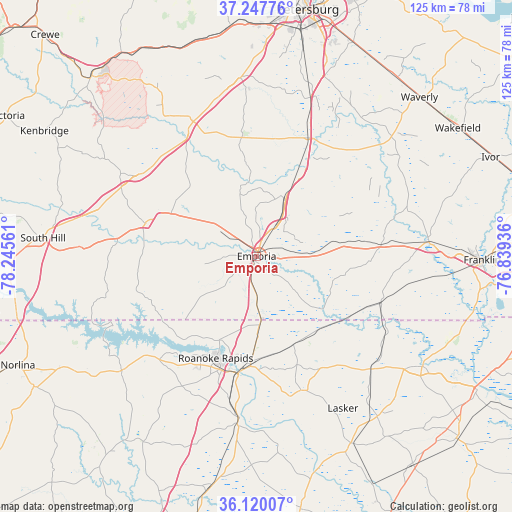
Emporia GPS coordinates[2]
36° 41' 9.528" North, 77° 32' 32.928" West
| Map corner | latitude | longitude |
|---|---|---|
| Upper-left | 37.24776°, | -78.24561° |
| Center: | 36.68598°, | -77.54248° |
| Lower-right: | 36.12007°, | -76.83936° |
| Map W x H: | 125.4×125.4 km | = 77.9×77.9mi |
| max Lat: | 71.29058° ⇑67.4% North |
| Emporia: | 36.68598° |
| min Lat: | ⇓32.6% South 19.06759° |
| min Long | Emporia | max Long |
| -171.73463° | -77.54248° | -66.98998° |
| W 78.8%⇐ | ⇒21.2% E |
Elevation
Elevation of Emporia is 40 m = 131 ft, and this is 254.8 m = 836 ft below average elevation for this country.
| Max E: |
3189 m = 10463 ft | 81.6% |
| Avg. | 294.8 m = 967 ft | |
| Emporia | 40 m = 131 ft | |
Min E: |
-60 m = -197 ft | 18.4% |
See also: United States elevation on elevation.city.
Geographical zone
Emporia is located in North temperate zone (between Tropic of Cancer and the Arctic Circle). Distance of this Northern Tropic circle is 1473.2 km =915.4 mi to South.| Distance of | km | miles | from Emporia |
|---|---|---|---|
| North Pole | 5928 | 3683.5 | to North |
| Arctic Circle | 3322.1 | 2064.3 | to North |
| Tropic Cancer | 1473.2 | 915.4 | to South |
| Equator | 4079.1 | 2534.6 | to South |


Nearby cities:
15 places around Emporia: (largest is in red/bold)
• Boykins
32.6 km =20.3 mi,  110°
110°
• Conway
39.4 km =24.5 mi,  134°
134°
• Courtland
42.4 km =26.3 mi,  85°
85°
• Garysburg
26.2 km =16.3 mi,  183°
183°
• Gaston
22.6 km =14 mi,  203°
203°
• Halifax
40 km =24.9 mi,  186°
186°
• Jackson
34.7 km =21.6 mi,  161°
161°
• Jarratt
15.7 km =9.8 mi,  24°
24°
• Lawrenceville
28.3 km =17.6 mi,  286°
286°
• Roanoke Rapids
26.9 km =16.7 mi, 201°
• Seaboard
23.6 km =14.7 mi, 157°
• South Rosemary
29.5 km =18.3 mi,  207°
207°
• South Weldon
30.5 km =19 mi, 190°
• Sussex
34.6 km =21.5 mi,  42°
42°
• Weldon
29.2 km =18.1 mi, 189°
Sources, notices
• [Note1] Compared only with cities in United States existing in our database
• [Src1] Map data: © OpenStreetMap contributors (CC-BY-SA)
• [Src2] Other city data from geonames.org with taken over terms of usage.
• [Src3] Geographical zone / Annual Mean Temperature by Robert A. Rohde @ Wikipedia
