Lawrenceville geodata
Lawrenceville (Virginia) is a seat of a second-order administrative division; located in United States in America/New_York (GMT-4) time zone. With population of 1,078 people, there are 15797 cities with bigger population in this country. Compared to other cities in United States, 67.1% of cities are located further ↑North; 78.1% of cities are located further ←West and 74.2% of cities have higher elevation than Lawrenceville. Note1


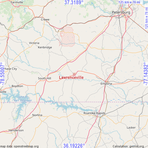
Lawrenceville GPS coordinates[2]
36° 45' 27.54" North, 77° 50' 48.984" West
| Map corner | latitude | longitude |
|---|---|---|
| Upper-left | 37.3189°, | -78.55007° |
| Center: | 36.75765°, | -77.84694° |
| Lower-right: | 36.19226°, | -77.14382° |
| Map W x H: | 125.3×125.3 km | = 77.9×77.9mi |
| max Lat: | 71.29058° ⇑67.1% North |
| Lawrenceville: | 36.75765° |
| min Lat: | ⇓32.9% South 19.06759° |
| min Long | Lawrenceville | max Long |
| -171.73463° | -77.84694° | -66.98998° |
| W 78.1%⇐ | ⇒21.9% E |
Elevation
Elevation of Lawrenceville is 76 m = 249 ft, and this is 218.8 m = 718 ft below average elevation for this country.
| Max E: |
3189 m = 10463 ft | 74.2% |
| Avg. | 294.8 m = 967 ft | |
| Lawrenceville | 76 m = 249 ft | |
Min E: |
-60 m = -197 ft | 25.8% |
See also: United States elevation on elevation.city.
Geographical zone
Lawrenceville is located in North temperate zone (between Tropic of Cancer and the Arctic Circle). Distance of this Northern Tropic circle is 1481.1 km =920.3 mi to South.| Distance of | km | miles | from Lawrenceville |
|---|---|---|---|
| North Pole | 5920 | 3678.5 | to North |
| Arctic Circle | 3314.1 | 2059.3 | to North |
| Tropic Cancer | 1481.1 | 920.3 | to South |
| Equator | 4087.1 | 2539.6 | to South |


Nearby cities:
15 places around Lawrenceville: (largest is in red/bold)
• Blackstone
38.3 km =23.8 mi,  339°
339°
• Bracey
31.7 km =19.7 mi,  236°
236°
• Dinwiddie
42.5 km =26.4 mi,  33°
33°
• Emporia
28.3 km =17.6 mi,  106°
106°
• Garysburg
42.7 km =26.5 mi,  142°
142°
• Gaston
33.8 km =21 mi,  147°
147°
• Jarratt
34.3 km =21.3 mi,  79°
79°
• Kenbridge
33.6 km =20.9 mi,  312°
312°
• La Crosse
23.4 km =14.5 mi,  254°
254°
• Littleton
36.4 km =22.6 mi,  189°
189°
• Roanoke Rapids
37.1 km =23.1 mi, 152°
• South Hill
25.4 km =15.8 mi,  262°
262°
• South Rosemary
36.6 km =22.7 mi,  158°
158°
• Victoria
42.9 km =26.7 mi, 307°
• Weldon
43.1 km =26.8 mi, 148°
Sources, notices
• [Note1] Compared only with cities in United States existing in our database
• [Src1] Map data: © OpenStreetMap contributors (CC-BY-SA)
• [Src2] Other city data from geonames.org with taken over terms of usage.
• [Src3] Geographical zone / Annual Mean Temperature by Robert A. Rohde @ Wikipedia
