Harrisonburg geodata
Harrisonburg (Virginia) is a seat of a second-order administrative division; located in United States in America/New_York (GMT-4) time zone. With population of 52,538 people, there are 890 cities with bigger population in this country. Compared to other cities in United States, 59% of cities are located further ↑North; 76.1% of cities are located further ←West and 84.1% of cities have lower elevation than Harrisonburg. Note1


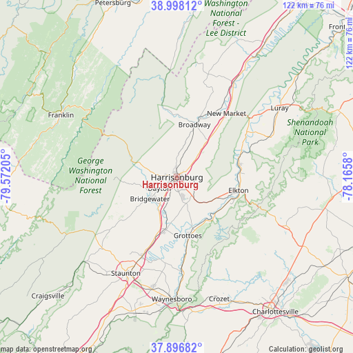
Harrisonburg GPS coordinates[2]
38° 26' 58.452" North, 78° 52' 8.112" West
| Map corner | latitude | longitude |
|---|---|---|
| Upper-left | 38.99812°, | -79.57205° |
| Center: | 38.44957°, | -78.86892° |
| Lower-right: | 37.89682°, | -78.1658° |
| Map W x H: | 122.5×122.5 km | = 76.1×76.1mi |
| max Lat: | 71.29058° ⇑59% North |
| Harrisonburg: | 38.44957° |
| min Lat: | ⇓41% South 19.06759° |
| min Long | Harrisonburg | max Long |
| -171.73463° | -78.86892° | -66.98998° |
| W 76.1%⇐ | ⇒23.9% E |
Elevation
Elevation of Harrisonburg is 406 m = 1332 ft, and this is 111.2 m = 365 ft above average elevation for this country.
| Max E: |
3189 m = 10463 ft | 15.9% |
| Harrisonburg | 406 m 1332 ft | |
| Avg. | 294.8 m = 967 ft | |
Min E: |
-60 m = -197 ft | 84.1% |
See also: Harrisonburg elevation on elevation.city.
Geographical zone
Harrisonburg is located in North temperate zone (between Tropic of Cancer and the Arctic Circle). Distance of this Northern Tropic circle is 1669.3 km =1037.3 mi to South.| Distance of | km | miles | from Harrisonburg |
|---|---|---|---|
| North Pole | 5731.9 | 3561.6 | to North |
| Arctic Circle | 3126 | 1942.4 | to North |
| Tropic Cancer | 1669.3 | 1037.3 | to South |
| Equator | 4275.2 | 2656.5 | to South |


Nearby cities:
15 places around Harrisonburg: (largest is in red/bold)
• Belmont Estates
4.4 km =2.7 mi,  274°
274°
• Bridgewater
12 km =7.5 mi,  231°
231°
• Broadway
19.2 km =11.9 mi,  18°
18°
• Dayton
7.2 km =4.5 mi,  237°
237°
• Elkton
21.9 km =13.6 mi,  102°
102°
• Grottoes
20.6 km =12.8 mi,  169°
169°
• Harriston
26 km =16.2 mi, 172°
• Massanetta Springs
6.2 km =3.9 mi,  151°
151°
• Massanutten
12.3 km =7.6 mi,  111°
111°
• Mount Sidney
22.8 km =14.2 mi,  200°
200°
• New Hope
28.2 km =17.5 mi,  186°
186°
• New Market
28 km =17.4 mi,  37°
37°
• Shenandoah
21.6 km =13.4 mi,  79°
79°
• Timberville
22.6 km =14 mi, 21°
• Weyers Cave
18.3 km =11.4 mi, 192°
Sources, notices
• [Note1] Compared only with cities in United States existing in our database
• [Src1] Map data: © OpenStreetMap contributors (CC-BY-SA)
• [Src2] Other city data from geonames.org with taken over terms of usage.
• [Src3] Geographical zone / Annual Mean Temperature by Robert A. Rohde @ Wikipedia
