Shenandoah geodata
Shenandoah (Virginia) is a populated place; located in United States in America/New_York (GMT-4) time zone. With population of 2,340 people, there are 10991 cities with bigger population in this country. Compared to other cities in United States, 58.8% of cities are located further ↑North; 76.7% of cities are located further ←West and 72% of cities have lower elevation than Shenandoah. Note1


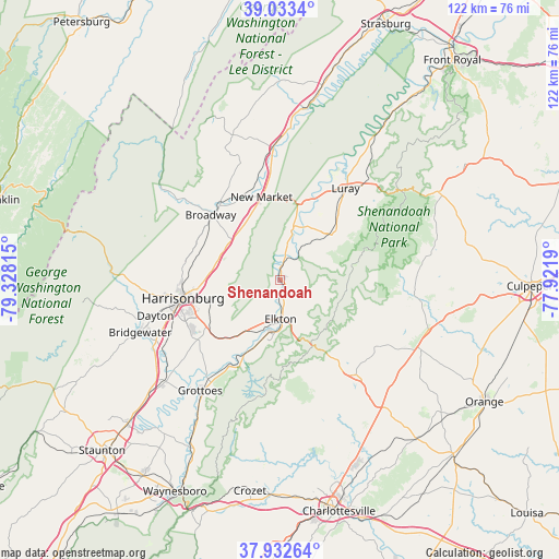
Shenandoah GPS coordinates[2]
38° 29' 6.432" North, 78° 37' 30.072" West
| Map corner | latitude | longitude |
|---|---|---|
| Upper-left | 39.0334°, | -79.32815° |
| Center: | 38.48512°, | -78.62502° |
| Lower-right: | 37.93264°, | -77.9219° |
| Map W x H: | 122.4×122.4 km | = 76.1×76.1mi |
| max Lat: | 71.29058° ⇑58.8% North |
| Shenandoah: | 38.48512° |
| min Lat: | ⇓41.2% South 19.06759° |
| min Long | Shenandoah | max Long |
| -171.73463° | -78.62502° | -66.98998° |
| W 76.7%⇐ | ⇒23.3% E |
Elevation
Elevation of Shenandoah is 296 m = 971 ft, and this is 1.2 m = 4 ft above average elevation for this country.
| Max E: |
3189 m = 10463 ft | 28% |
| Shenandoah | 296 m 971 ft | |
| Avg. | 294.8 m = 967 ft | |
Min E: |
-60 m = -197 ft | 72% |
See also: United States elevation on elevation.city.
Geographical zone
Shenandoah is located in North temperate zone (between Tropic of Cancer and the Arctic Circle). Distance of this Northern Tropic circle is 1673.2 km =1039.7 mi to South.| Distance of | km | miles | from Shenandoah |
|---|---|---|---|
| North Pole | 5727.9 | 3559.2 | to North |
| Arctic Circle | 3122 | 1939.9 | to North |
| Tropic Cancer | 1673.2 | 1039.7 | to South |
| Equator | 4279.1 | 2658.9 | to South |


Nearby cities:
15 places around Shenandoah: (largest is in red/bold)
• Belmont Estates
25.9 km =16.1 mi,  262°
262°
• Broadway
20.8 km =12.9 mi,  313°
313°
• Dayton
28.4 km =17.6 mi,  254°
254°
• Elkton
8.6 km =5.3 mi,  179°
179°
• Grottoes
29.9 km =18.6 mi,  215°
215°
• Harrisonburg
21.6 km =13.4 mi, 259°
• Luray
24.7 km =15.3 mi,  35°
35°
• Massanetta Springs
20.5 km =12.7 mi,  242°
242°
• Massanutten
12.9 km =8 mi,  229°
229°
• Mount Jackson
29 km =18 mi,  357°
357°
• New Market
18.5 km =11.5 mi,  347°
347°
• Stanardsville
26.4 km =16.4 mi,  142°
142°
• Stanley
14.6 km =9.1 mi,  46°
46°
• Timberville
21.5 km =13.4 mi,  322°
322°
• Twin Lakes
30.6 km =19 mi,  148°
148°
Sources, notices
• [Note1] Compared only with cities in United States existing in our database
• [Src1] Map data: © OpenStreetMap contributors (CC-BY-SA)
• [Src2] Other city data from geonames.org with taken over terms of usage.
• [Src3] Geographical zone / Annual Mean Temperature by Robert A. Rohde @ Wikipedia
