Hybla Valley geodata
Hybla Valley (Virginia) is a populated place; located in United States in America/New_York (GMT-4) time zone. With population of 15,801 people, there are 3099 cities with bigger population in this country. Compared to other cities in United States, 57% of cities are located further ↑North; 80.2% of cities are located further ←West and 93.9% of cities have higher elevation than Hybla Valley. Note1


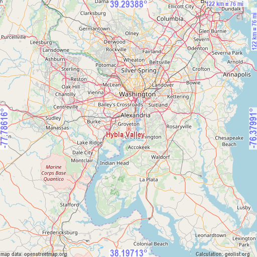
Hybla Valley GPS coordinates[2]
38° 44' 51.396" North, 77° 4' 58.908" West
| Map corner | latitude | longitude |
|---|---|---|
| Upper-left | 39.29388°, | -77.78616° |
| Center: | 38.74761°, | -77.08303° |
| Lower-right: | 38.19713°, | -76.37991° |
| Map W x H: | 121.9×121.9 km | = 75.7×75.7mi |
| max Lat: | 71.29058° ⇑57% North |
| Hybla Valley: | 38.74761° |
| min Lat: | ⇓43% South 19.06759° |
| min Long | Hybla Valley | max Long |
| -171.73463° | -77.08303° | -66.98998° |
| W 80.2%⇐ | ⇒19.8% E |
Elevation
Elevation of Hybla Valley is 10 m = 33 ft, and this is 284.8 m = 934 ft below average elevation for this country.
| Max E: |
3189 m = 10463 ft | 93.9% |
| Avg. | 294.8 m = 967 ft | |
| Hybla Valley | 10 m = 33 ft | |
Min E: |
-60 m = -197 ft | 6.1% |
See also: United States elevation on elevation.city.
Geographical zone
Hybla Valley is located in North temperate zone (between Tropic of Cancer and the Arctic Circle). Distance of this Northern Tropic circle is 1702.4 km =1057.8 mi to South.| Distance of | km | miles | from Hybla Valley |
|---|---|---|---|
| North Pole | 5698.7 | 3541 | to North |
| Arctic Circle | 3092.8 | 1921.8 | to North |
| Tropic Cancer | 1702.4 | 1057.8 | to South |
| Equator | 4308.3 | 2677.1 | to South |


Nearby cities:
15 places around Hybla Valley: (largest is in red/bold)
• Alexandria
7.1 km =4.4 mi,  26°
26°
• Belle Haven
4.5 km =2.8 mi,  22°
22°
• Fort Belvoir
6.7 km =4.2 mi,  233°
233°
• Fort Hunt
2.7 km =1.7 mi,  127°
127°
• Fort Washington
6.9 km =4.3 mi, 130°
• Franconia
6.7 km =4.2 mi,  304°
304°
• Friendly
9.1 km =5.7 mi,  87°
87°
• Groveton
2.2 km =1.4 mi,  356°
356°
• Hayfield
4.6 km =2.9 mi,  275°
275°
• Huntington
5.1 km =3.2 mi,  12°
12°
• Mount Vernon
3.8 km =2.4 mi,  213°
213°
• National Harbor
7.1 km =4.4 mi,  56°
56°
• Newington
8.9 km =5.5 mi,  263°
263°
• Rose Hill
5.2 km =3.2 mi,  330°
330°
• Woodlawn
5.5 km =3.4 mi, 231°
Sources, notices
• [Note1] Compared only with cities in United States existing in our database
• [Src1] Map data: © OpenStreetMap contributors (CC-BY-SA)
• [Src2] Other city data from geonames.org with taken over terms of usage.
• [Src3] Geographical zone / Annual Mean Temperature by Robert A. Rohde @ Wikipedia
