Alexandria geodata
Alexandria (Virginia) is a seat of a second-order administrative division; located in United States in America/New_York (GMT-4) time zone. With population of 153,511 people, there are 186 cities with bigger population in this country. Compared to other cities in United States, 56.5% of cities are located further ↑North; 80.4% of cities are located further ←West and 90.5% of cities have higher elevation than Alexandria. Note1


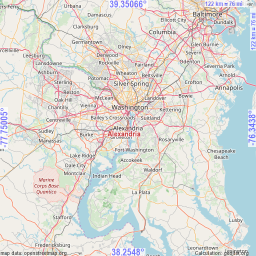
Alexandria GPS coordinates[2]
38° 48' 17.424" North, 77° 2' 48.912" West
| Map corner | latitude | longitude |
|---|---|---|
| Upper-left | 39.35066°, | -77.75005° |
| Center: | 38.80484°, | -77.04692° |
| Lower-right: | 38.2548°, | -76.3438° |
| Map W x H: | 121.8×121.8 km | = 75.7×75.7mi |
| max Lat: | 71.29058° ⇑56.5% North |
| Alexandria: | 38.80484° |
| min Lat: | ⇓43.5% South 19.06759° |
| min Long | Alexandria | max Long |
| -171.73463° | -77.04692° | -66.98998° |
| W 80.4%⇐ | ⇒19.6% E |
Elevation
Elevation of Alexandria is 15 m = 49 ft, and this is 279.8 m = 918 ft below average elevation for this country.
| Max E: |
3189 m = 10463 ft | 90.5% |
| Avg. | 294.8 m = 967 ft | |
| Alexandria | 15 m = 49 ft | |
Min E: |
-60 m = -197 ft | 9.5% |
See also: Alexandria elevation on elevation.city.
Geographical zone
Alexandria is located in North temperate zone (between Tropic of Cancer and the Arctic Circle). Distance of this Northern Tropic circle is 1708.8 km =1061.8 mi to South.| Distance of | km | miles | from Alexandria |
|---|---|---|---|
| North Pole | 5692.4 | 3537.1 | to North |
| Arctic Circle | 3086.5 | 1917.9 | to North |
| Tropic Cancer | 1708.8 | 1061.8 | to South |
| Equator | 4314.7 | 2681 | to South |


Nearby cities:
15 places around Alexandria: (largest is in red/bold)
• Belle Haven
2.6 km =1.6 mi,  212°
212°
• Forest Heights
4.3 km =2.7 mi,  82°
82°
• Fort Hunt
8.1 km =5 mi,  186°
186°
• Friendly
8.4 km =5.2 mi,  134°
134°
• Glassmanor
4.5 km =2.8 mi,  69°
69°
• Groveton
5.3 km =3.3 mi,  218°
218°
• Hillcrest Heights
8.2 km =5.1 mi, 67°
• Huntington
2.5 km =1.6 mi,  236°
236°
• Hybla Valley
7.1 km =4.4 mi, 206°
• Lincolnia
8.5 km =5.3 mi,  280°
280°
• Marlow Heights
8.8 km =5.5 mi, 68°
• National Harbor
3.7 km =2.3 mi, 131°
• Oxon Hill
5 km =3.1 mi,  91°
91°
• Oxon Hill-Glassmanor
6.3 km =3.9 mi,  98°
98°
• Rose Hill
6 km =3.7 mi,  252°
252°
Sources, notices
• [Note1] Compared only with cities in United States existing in our database
• [Src1] Map data: © OpenStreetMap contributors (CC-BY-SA)
• [Src2] Other city data from geonames.org with taken over terms of usage.
• [Src3] Geographical zone / Annual Mean Temperature by Robert A. Rohde @ Wikipedia
