Laurel Park geodata
Laurel Park (Virginia) is a populated place; located in United States in America/New_York (GMT-4) time zone. With population of 675 people, there are 18918 cities with bigger population in this country. Compared to other cities in United States, 67.4% of cities are located further ↑North; 74.2% of cities are located further ←West and 60.3% of cities have lower elevation than Laurel Park. Note1


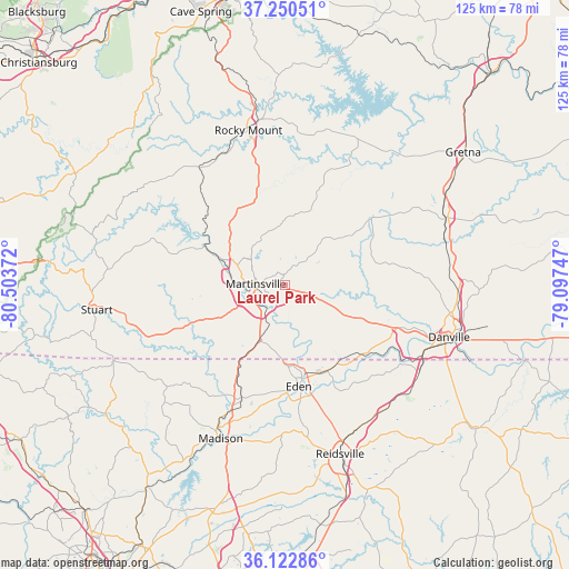
Laurel Park GPS coordinates[2]
36° 41' 19.5" North, 79° 48' 2.124" West
| Map corner | latitude | longitude |
|---|---|---|
| Upper-left | 37.25051°, | -80.50372° |
| Center: | 36.68875°, | -79.80059° |
| Lower-right: | 36.12286°, | -79.09747° |
| Map W x H: | 125.4×125.4 km | = 77.9×77.9mi |
| max Lat: | 71.29058° ⇑67.4% North |
| Laurel Park: | 36.68875° |
| min Lat: | ⇓32.6% South 19.06759° |
| min Long | Laurel Park | max Long |
| -171.73463° | -79.80059° | -66.98998° |
| W 74.2%⇐ | ⇒25.8% E |
Elevation
Elevation of Laurel Park is 241 m = 791 ft, and this is 53.8 m = 177 ft below average elevation for this country.
| Max E: |
3189 m = 10463 ft | 39.7% |
| Avg. | 294.8 m = 967 ft | |
| Laurel Park | 241 m = 791 ft | |
Min E: |
-60 m = -197 ft | 60.3% |
See also: United States elevation on elevation.city.
Geographical zone
Laurel Park is located in North temperate zone (between Tropic of Cancer and the Arctic Circle). Distance of this Northern Tropic circle is 1473.5 km =915.6 mi to South.| Distance of | km | miles | from Laurel Park |
|---|---|---|---|
| North Pole | 5927.7 | 3683.3 | to North |
| Arctic Circle | 3321.8 | 2064.1 | to North |
| Tropic Cancer | 1473.5 | 915.6 | to South |
| Equator | 4079.4 | 2534.8 | to South |


Nearby cities:
15 places around Laurel Park: (largest is in red/bold)
• Bassett
18.6 km =11.6 mi,  294°
294°
• Chatmoss
3.7 km =2.3 mi,  196°
196°
• Collinsville
10.6 km =6.6 mi, 286°
• Eden
22.5 km =14 mi,  172°
172°
• Fieldale
12.4 km =7.7 mi,  275°
275°
• Henry Fork
31.5 km =19.6 mi,  348°
348°
• Horse Pasture
15 km =9.3 mi,  243°
243°
• Martinsville
6.4 km =4 mi,  272°
272°
• Oak Level
18.5 km =11.5 mi,  319°
319°
• Pannill Fork
19.1 km =11.9 mi, 276°
• Ridgeway
13.5 km =8.4 mi, 202°
• Stanleytown
15.7 km =9.8 mi, 293°
• Stoneville
26.5 km =16.5 mi, 201°
• Villa Heights
9.3 km =5.8 mi, 275°
• Wentworth
32.2 km =20 mi,  175°
175°
Sources, notices
• [Note1] Compared only with cities in United States existing in our database
• [Src1] Map data: © OpenStreetMap contributors (CC-BY-SA)
• [Src2] Other city data from geonames.org with taken over terms of usage.
• [Src3] Geographical zone / Annual Mean Temperature by Robert A. Rohde @ Wikipedia
