Wentworth geodata
Wentworth (North Carolina) is a seat of a second-order administrative division; located in United States in America/New_York (GMT-4) time zone. With population of 2,765 people, there are 10052 cities with bigger population in this country. Compared to other cities in United States, 68.5% of cities are located further ↑North; 74.3% of cities are located further ←West and 57.2% of cities have lower elevation than Wentworth. Note1
Administrative division(s):
- Level 1: North Carolina
- Level 2: Rockingham County
- Level 3: Township of Wentworth


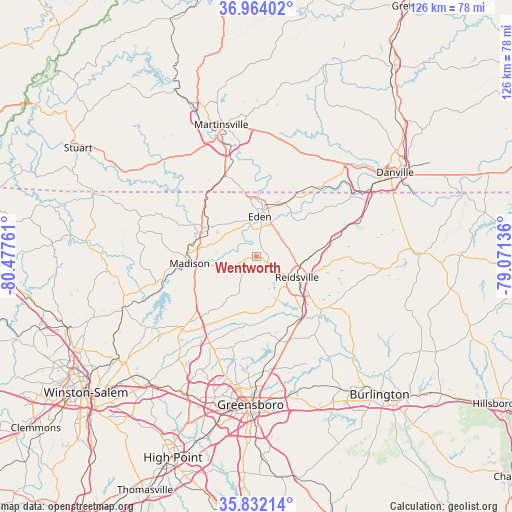
Wentworth GPS coordinates[2]
36° 24' 0.504" North, 79° 46' 28.128" West
| Map corner | latitude | longitude |
|---|---|---|
| Upper-left | 36.96402°, | -80.47761° |
| Center: | 36.40014°, | -79.77448° |
| Lower-right: | 35.83214°, | -79.07136° |
| Map W x H: | 125.9×125.9 km | = 78.2×78.2mi |
| max Lat: | 71.29058° ⇑68.5% North |
| Wentworth: | 36.40014° |
| min Lat: | ⇓31.5% South 19.06759° |
| min Long | Wentworth | max Long |
| -171.73463° | -79.77448° | -66.98998° |
| W 74.3%⇐ | ⇒25.7% E |
Elevation
Elevation of Wentworth is 227 m = 745 ft, and this is 67.8 m = 222 ft below average elevation for this country.
| Max E: |
3189 m = 10463 ft | 42.8% |
| Avg. | 294.8 m = 967 ft | |
| Wentworth | 227 m = 745 ft | |
Min E: |
-60 m = -197 ft | 57.2% |
See also: United States elevation on elevation.city.
Geographical zone
Wentworth is located in North temperate zone (between Tropic of Cancer and the Arctic Circle). Distance of this Northern Tropic circle is 1441.4 km =895.6 mi to South.| Distance of | km | miles | from Wentworth |
|---|---|---|---|
| North Pole | 5959.7 | 3703.2 | to North |
| Arctic Circle | 3353.9 | 2084 | to North |
| Tropic Cancer | 1441.4 | 895.6 | to South |
| Equator | 4047.3 | 2514.9 | to South |


Nearby cities:
15 places around Wentworth: (largest is in red/bold)
• Chatmoss
28.7 km =17.8 mi,  353°
353°
• Eden
9.8 km =6.1 mi,  4°
4°
• Horse Pasture
29.9 km =18.6 mi,  328°
328°
• Laurel Park
32.2 km =20 mi,  355°
355°
• Madison
16.6 km =10.3 mi,  264°
264°
• Martinsville
33.6 km =20.9 mi,  344°
344°
• Mayodan
17.3 km =10.7 mi,  274°
274°
• McLeansville
34.2 km =21.3 mi,  162°
162°
• Oak Ridge
31.7 km =19.7 mi,  217°
217°
• Ossipee
34.7 km =21.6 mi,  136°
136°
• Reidsville
11.1 km =6.9 mi,  117°
117°
• Ridgeway
21 km =13 mi, 339°
• Stokesdale
25.8 km =16 mi,  225°
225°
• Stoneville
14 km =8.7 mi,  301°
301°
• Summerfield
24.3 km =15.1 mi,  208°
208°
Sources, notices
• [Note1] Compared only with cities in United States existing in our database
• [Src1] Map data: © OpenStreetMap contributors (CC-BY-SA)
• [Src2] Other city data from geonames.org with taken over terms of usage.
• [Src3] Geographical zone / Annual Mean Temperature by Robert A. Rohde @ Wikipedia
