Oak Level geodata
Oak Level (Virginia) is a populated place; located in United States in America/New_York (GMT-4) time zone. With population of 857 people, there are 17316 cities with bigger population in this country. Compared to other cities in United States, 66.9% of cities are located further ↑North; 73.6% of cities are located further ←West and 82.5% of cities have lower elevation than Oak Level. Note1


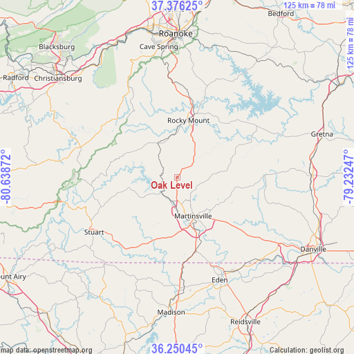
Oak Level GPS coordinates[2]
36° 48' 55.512" North, 79° 56' 8.124" West
| Map corner | latitude | longitude |
|---|---|---|
| Upper-left | 37.37625°, | -80.63872° |
| Center: | 36.81542°, | -79.93559° |
| Lower-right: | 36.25045°, | -79.23247° |
| Map W x H: | 125.2×125.2 km | = 77.8×77.8mi |
| max Lat: | 71.29058° ⇑66.9% North |
| Oak Level: | 36.81542° |
| min Lat: | ⇓33.1% South 19.06759° |
| min Long | Oak Level | max Long |
| -171.73463° | -79.93559° | -66.98998° |
| W 73.6%⇐ | ⇒26.4% E |
Elevation
Elevation of Oak Level is 382 m = 1253 ft, and this is 87.2 m = 286 ft above average elevation for this country.
| Max E: |
3189 m = 10463 ft | 17.5% |
| Oak Level | 382 m 1253 ft | |
| Avg. | 294.8 m = 967 ft | |
Min E: |
-60 m = -197 ft | 82.5% |
See also: United States elevation on elevation.city.
Geographical zone
Oak Level is located in North temperate zone (between Tropic of Cancer and the Arctic Circle). Distance of this Northern Tropic circle is 1487.6 km =924.4 mi to South.| Distance of | km | miles | from Oak Level |
|---|---|---|---|
| North Pole | 5913.6 | 3674.5 | to North |
| Arctic Circle | 3307.7 | 2055.3 | to North |
| Tropic Cancer | 1487.6 | 924.4 | to South |
| Equator | 4093.5 | 2543.6 | to South |


Nearby cities:
15 places around Oak Level: (largest is in red/bold)
• Bassett
7.9 km =4.9 mi,  217°
217°
• Chatmoss
20.8 km =12.9 mi,  148°
148°
• Collinsville
11.3 km =7 mi,  170°
170°
• Ferrum
13.8 km =8.6 mi,  329°
329°
• Fieldale
12.8 km =8 mi,  181°
181°
• Henry Fork
17.7 km =11 mi,  19°
19°
• Horse Pasture
20.8 km =12.9 mi, 183°
• Laurel Park
18.5 km =11.5 mi,  139°
139°
• Martinsville
14.9 km =9.3 mi,  157°
157°
• Pannill Fork
13.7 km =8.5 mi,  210°
210°
• Patrick Springs
30.1 km =18.7 mi,  230°
230°
• Ridgeway
27.4 km =17 mi, 165°
• Rocky Mount
20.6 km =12.8 mi,  10°
10°
• Stanleytown
8.3 km =5.2 mi,  197°
197°
• Villa Heights
13.4 km =8.3 mi, 167°
Sources, notices
• [Note1] Compared only with cities in United States existing in our database
• [Src1] Map data: © OpenStreetMap contributors (CC-BY-SA)
• [Src2] Other city data from geonames.org with taken over terms of usage.
• [Src3] Geographical zone / Annual Mean Temperature by Robert A. Rohde @ Wikipedia
