Bracey geodata
Bracey (Virginia) is a populated place; located in United States in America/New_York (GMT-4) time zone. With population of 1,554 people, there are 13458 cities with bigger population in this country. Compared to other cities in United States, 67.7% of cities are located further ↑North; 77.5% of cities are located further ←West and 68.3% of cities have higher elevation than Bracey. Note1


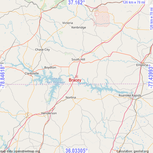
Bracey GPS coordinates[2]
36° 35' 58.524" North, 78° 8' 34.98" West
| Map corner | latitude | longitude |
|---|---|---|
| Upper-left | 37.162°, | -78.84618° |
| Center: | 36.59959°, | -78.14305° |
| Lower-right: | 36.03305°, | -77.43993° |
| Map W x H: | 125.5×125.5 km | = 78×78mi |
| max Lat: | 71.29058° ⇑67.7% North |
| Bracey: | 36.59959° |
| min Lat: | ⇓32.3% South 19.06759° |
| min Long | Bracey | max Long |
| -171.73463° | -78.14305° | -66.98998° |
| W 77.5%⇐ | ⇒22.5% E |
Elevation
Elevation of Bracey is 111 m = 364 ft, and this is 183.8 m = 603 ft below average elevation for this country.
| Max E: |
3189 m = 10463 ft | 68.3% |
| Avg. | 294.8 m = 967 ft | |
| Bracey | 111 m = 364 ft | |
Min E: |
-60 m = -197 ft | 31.7% |
See also: United States elevation on elevation.city.
Geographical zone
Bracey is located in North temperate zone (between Tropic of Cancer and the Arctic Circle). Distance of this Northern Tropic circle is 1463.6 km =909.4 mi to South.| Distance of | km | miles | from Bracey |
|---|---|---|---|
| North Pole | 5937.6 | 3689.5 | to North |
| Arctic Circle | 3331.7 | 2070.2 | to North |
| Tropic Cancer | 1463.6 | 909.4 | to South |
| Equator | 4069.5 | 2528.7 | to South |


Nearby cities:
15 places around Bracey: (largest is in red/bold)
• Boydton
23.1 km =14.4 mi,  289°
289°
• Chase City
35.8 km =22.2 mi,  308°
308°
• Clarksville
37 km =23 mi,  274°
274°
• Henderson
37.8 km =23.5 mi,  217°
217°
• Hollister
42.5 km =26.4 mi,  154°
154°
• Kenbridge
40.3 km =25 mi,  2°
2°
• La Crosse
11.8 km =7.3 mi,  19°
19°
• Lawrenceville
31.7 km =19.7 mi,  56°
56°
• Littleton
27.6 km =17.1 mi,  131°
131°
• Lunenburg
41.6 km =25.8 mi,  344°
344°
• Norlina
17.8 km =11.1 mi,  196°
196°
• South Henderson
40.1 km =24.9 mi, 216°
• South Hill
14.2 km =8.8 mi,  5°
5°
• South Rosemary
43.1 km =26.8 mi,  112°
112°
• Warrenton
22.4 km =13.9 mi,  182°
182°
Sources, notices
• [Note1] Compared only with cities in United States existing in our database
• [Src1] Map data: © OpenStreetMap contributors (CC-BY-SA)
• [Src2] Other city data from geonames.org with taken over terms of usage.
• [Src3] Geographical zone / Annual Mean Temperature by Robert A. Rohde @ Wikipedia
