McLean geodata
McLean (Virginia) is a populated place; located in United States in America/New_York (GMT-4) time zone. With population of 48,115 people, there are 999 cities with bigger population in this country. Compared to other cities in United States, 55.6% of cities are located further ↑North; 79.9% of cities are located further ←West and 71.7% of cities have higher elevation than McLean. Note1


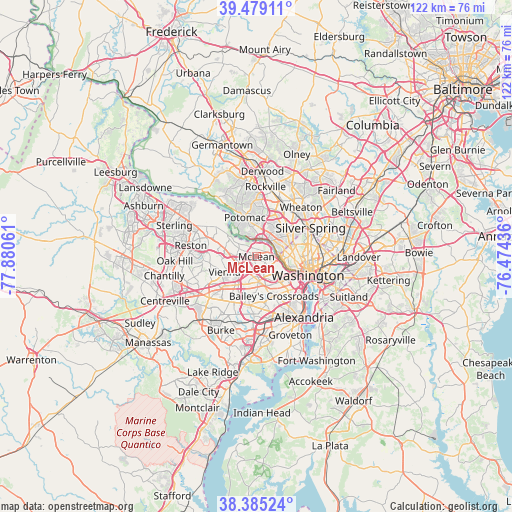
McLean GPS coordinates[2]
38° 56' 3.408" North, 77° 10' 38.928" West
| Map corner | latitude | longitude |
|---|---|---|
| Upper-left | 39.47911°, | -77.88061° |
| Center: | 38.93428°, | -77.17748° |
| Lower-right: | 38.38524°, | -76.47436° |
| Map W x H: | 121.6×121.6 km | = 75.6×75.6mi |
| max Lat: | 71.29058° ⇑55.6% North |
| McLean: | 38.93428° |
| min Lat: | ⇓44.4% South 19.06759° |
| min Long | McLean | max Long |
| -171.73463° | -77.17748° | -66.98998° |
| W 79.9%⇐ | ⇒20.1% E |
Elevation
Elevation of McLean is 91 m = 299 ft, and this is 203.8 m = 669 ft below average elevation for this country.
| Max E: |
3189 m = 10463 ft | 71.7% |
| Avg. | 294.8 m = 967 ft | |
| McLean | 91 m = 299 ft | |
Min E: |
-60 m = -197 ft | 28.3% |
See also: McLean elevation on elevation.city.
Geographical zone
McLean is located in North temperate zone (between Tropic of Cancer and the Arctic Circle). Distance of this Northern Tropic circle is 1723.2 km =1070.7 mi to South.| Distance of | km | miles | from McLean |
|---|---|---|---|
| North Pole | 5678 | 3528.1 | to North |
| Arctic Circle | 3072.1 | 1908.9 | to North |
| Tropic Cancer | 1723.2 | 1070.7 | to South |
| Equator | 4329.1 | 2690 | to South |


Nearby cities:
15 places around McLean: (largest is in red/bold)
• Bethesda
8.4 km =5.2 mi,  52°
52°
• Brookmont
5 km =3.1 mi,  80°
80°
• Cabin John
4.9 km =3 mi,  20°
20°
• Dunn Loring
5.9 km =3.7 mi,  220°
220°
• Falls Church
5.8 km =3.6 mi,  174°
174°
• Friendship Village
8.3 km =5.2 mi,  67°
67°
• Idylwood
5.3 km =3.3 mi,  214°
214°
• Jefferson
7.8 km =4.8 mi,  186°
186°
• Merrifield
7.9 km =4.9 mi, 212°
• Pimmit Hills
3.1 km =1.9 mi, 220°
• Seven Corners
7.2 km =4.5 mi,  164°
164°
• Somerset
7.9 km =4.9 mi,  63°
63°
• Tysons Corner
4.9 km =3 mi,  249°
249°
• Vienna
8.4 km =5.2 mi,  244°
244°
• West Falls Church
4.9 km =3 mi, 187°
Sources, notices
• [Note1] Compared only with cities in United States existing in our database
• [Src1] Map data: © OpenStreetMap contributors (CC-BY-SA)
• [Src2] Other city data from geonames.org with taken over terms of usage.
• [Src3] Geographical zone / Annual Mean Temperature by Robert A. Rohde @ Wikipedia
