Patrick Springs geodata
Patrick Springs (Virginia) is a populated place; located in United States in America/New_York (GMT-4) time zone. With population of 1,845 people, there are 12391 cities with bigger population in this country. Compared to other cities in United States, 67.6% of cities are located further ↑North; 72.3% of cities are located further ←West and 82.6% of cities have lower elevation than Patrick Springs. Note1


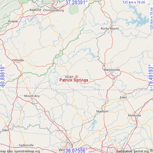
Patrick Springs GPS coordinates[2]
36° 38' 30.48" North, 80° 11' 42.18" West
| Map corner | latitude | longitude |
|---|---|---|
| Upper-left | 37.20391°, | -80.89818° |
| Center: | 36.6418°, | -80.19505° |
| Lower-right: | 36.07556°, | -79.49193° |
| Map W x H: | 125.5×125.5 km | = 78×78mi |
| max Lat: | 71.29058° ⇑67.6% North |
| Patrick Springs: | 36.6418° |
| min Lat: | ⇓32.4% South 19.06759° |
| min Long | Patrick Springs | max Long |
| -171.73463° | -80.19505° | -66.98998° |
| W 72.3%⇐ | ⇒27.7% E |
Elevation
Elevation of Patrick Springs is 384 m = 1260 ft, and this is 89.2 m = 293 ft above average elevation for this country.
| Max E: |
3189 m = 10463 ft | 17.4% |
| Patrick Springs | 384 m 1260 ft | |
| Avg. | 294.8 m = 967 ft | |
Min E: |
-60 m = -197 ft | 82.6% |
See also: United States elevation on elevation.city.
Geographical zone
Patrick Springs is located in North temperate zone (between Tropic of Cancer and the Arctic Circle). Distance of this Northern Tropic circle is 1468.3 km =912.4 mi to South.| Distance of | km | miles | from Patrick Springs |
|---|---|---|---|
| North Pole | 5932.9 | 3686.5 | to North |
| Arctic Circle | 3327 | 2067.3 | to North |
| Tropic Cancer | 1468.3 | 912.4 | to South |
| Equator | 4074.2 | 2531.6 | to South |


Nearby cities:
15 places around Patrick Springs: (largest is in red/bold)
• Bassett
22.4 km =13.9 mi,  54°
54°
• Collinsville
26.2 km =16.3 mi,  71°
71°
• Danbury
25.9 km =16.1 mi,  182°
182°
• Fieldale
23.8 km =14.8 mi, 74°
• Floyd
32 km =19.9 mi,  339°
339°
• Horse Pasture
21.8 km =13.5 mi,  93°
93°
• Martinsville
29.3 km =18.2 mi,  79°
79°
• Mayodan
32.7 km =20.3 mi,  141°
141°
• Oak Level
30.1 km =18.7 mi, 50°
• Pannill Fork
17.9 km =11.1 mi, 65°
• Ridgeway
30.9 km =19.2 mi,  103°
103°
• Stanleytown
23.6 km =14.7 mi,  61°
61°
• Stoneville
32.3 km =20.1 mi,  127°
127°
• Stuart
6.3 km =3.9 mi,  269°
269°
• Villa Heights
26.7 km =16.6 mi, 76°
Sources, notices
• [Note1] Compared only with cities in United States existing in our database
• [Src1] Map data: © OpenStreetMap contributors (CC-BY-SA)
• [Src2] Other city data from geonames.org with taken over terms of usage.
• [Src3] Geographical zone / Annual Mean Temperature by Robert A. Rohde @ Wikipedia
