Rushmere geodata
Rushmere (Virginia) is a populated place; located in United States in America/New_York (GMT-4) time zone. With population of 1,018 people, there are 16165 cities with bigger population in this country. Compared to other cities in United States, 65.9% of cities are located further ↑North; 82% of cities are located further ←West and 87.4% of cities have higher elevation than Rushmere. Note1


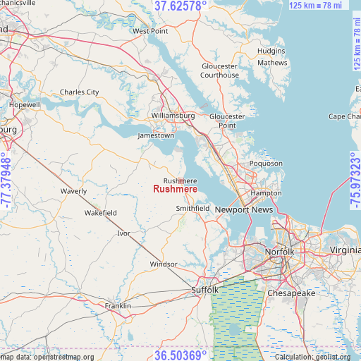
Rushmere GPS coordinates[2]
37° 4' 0.516" North, 76° 40' 34.86" West
| Map corner | latitude | longitude |
|---|---|---|
| Upper-left | 37.62578°, | -77.37948° |
| Center: | 37.06681°, | -76.67635° |
| Lower-right: | 36.50369°, | -75.97323° |
| Map W x H: | 124.8×124.8 km | = 77.5×77.5mi |
| max Lat: | 71.29058° ⇑65.9% North |
| Rushmere: | 37.06681° |
| min Lat: | ⇓34.1% South 19.06759° |
| min Long | Rushmere | max Long |
| -171.73463° | -76.67635° | -66.98998° |
| W 82%⇐ | ⇒18% E |
Elevation
Elevation of Rushmere is 22 m = 72 ft, and this is 272.8 m = 895 ft below average elevation for this country.
| Max E: |
3189 m = 10463 ft | 87.4% |
| Avg. | 294.8 m = 967 ft | |
| Rushmere | 22 m = 72 ft | |
Min E: |
-60 m = -197 ft | 12.6% |
See also: United States elevation on elevation.city.
Geographical zone
Rushmere is located in North temperate zone (between Tropic of Cancer and the Arctic Circle). Distance of this Northern Tropic circle is 1515.5 km =941.7 mi to South.| Distance of | km | miles | from Rushmere |
|---|---|---|---|
| North Pole | 5885.6 | 3657.1 | to North |
| Arctic Circle | 3279.7 | 2037.9 | to North |
| Tropic Cancer | 1515.5 | 941.7 | to South |
| Equator | 4121.4 | 2560.9 | to South |


Nearby cities:
15 places around Rushmere: (largest is in red/bold)
• Benns Church
16.4 km =10.2 mi,  150°
150°
• Carrollton
16.8 km =10.4 mi,  142°
142°
• East Hampton
30.8 km =19.1 mi,  96°
96°
• Gloucester Point
26.2 km =16.3 mi,  37°
37°
• Hampton
29.7 km =18.5 mi, 97°
• Isle of Wight
17.9 km =11.1 mi,  188°
188°
• Newport News
18.4 km =11.4 mi,  84°
84°
• Poquoson
30 km =18.6 mi, 78°
• Smithfield
10.2 km =6.3 mi,  156°
156°
• Surry
16.2 km =10.1 mi,  299°
299°
• Wakefield
29.9 km =18.6 mi,  248°
248°
• Williamsburg
22.8 km =14.2 mi,  353°
353°
• Williamsburg
23.7 km =14.7 mi, 345°
• Windsor
29.3 km =18.2 mi, 191°
• Yorktown
24.2 km =15 mi, 37°
Sources, notices
• [Note1] Compared only with cities in United States existing in our database
• [Src1] Map data: © OpenStreetMap contributors (CC-BY-SA)
• [Src2] Other city data from geonames.org with taken over terms of usage.
• [Src3] Geographical zone / Annual Mean Temperature by Robert A. Rohde @ Wikipedia
