Williamsburg geodata
Williamsburg (Virginia) is a seat of a second-order administrative division; located in United States in America/New_York (GMT-4) time zone. With population of 15,052 people, there are 3239 cities with bigger population in this country. Compared to other cities in United States, 65% of cities are located further ↑North; 81.9% of cities are located further ←West and 83.6% of cities have higher elevation than Williamsburg. Note1


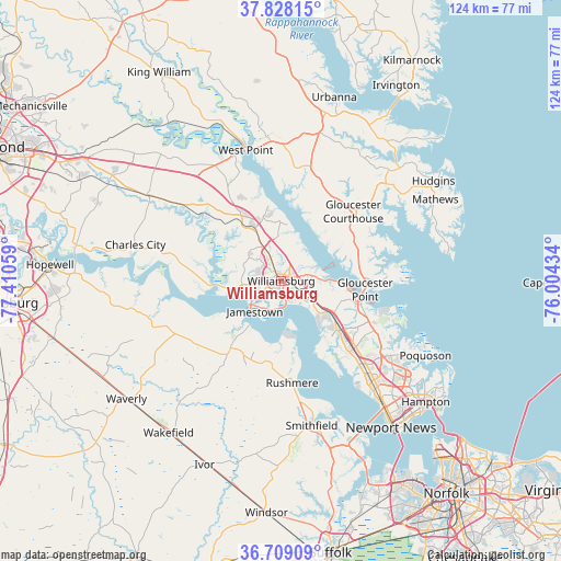
Williamsburg GPS coordinates[2]
37° 16' 14.52" North, 76° 42' 26.856" West
| Map corner | latitude | longitude |
|---|---|---|
| Upper-left | 37.82815°, | -77.41059° |
| Center: | 37.2707°, | -76.70746° |
| Lower-right: | 36.70909°, | -76.00434° |
| Map W x H: | 124.4×124.4 km | = 77.3×77.3mi |
| max Lat: | 71.29058° ⇑65% North |
| Williamsburg: | 37.2707° |
| min Lat: | ⇓35% South 19.06759° |
| min Long | Williamsburg | max Long |
| -171.73463° | -76.70746° | -66.98998° |
| W 81.9%⇐ | ⇒18.1% E |
Elevation
Elevation of Williamsburg is 33 m = 108 ft, and this is 261.8 m = 859 ft below average elevation for this country.
| Max E: |
3189 m = 10463 ft | 83.6% |
| Avg. | 294.8 m = 967 ft | |
| Williamsburg | 33 m = 108 ft | |
Min E: |
-60 m = -197 ft | 16.4% |
See also: United States elevation on elevation.city.
Geographical zone
Williamsburg is located in North temperate zone (between Tropic of Cancer and the Arctic Circle). Distance of this Northern Tropic circle is 1538.2 km =955.8 mi to South.| Distance of | km | miles | from Williamsburg |
|---|---|---|---|
| North Pole | 5862.9 | 3643 | to North |
| Arctic Circle | 3257.1 | 2023.9 | to North |
| Tropic Cancer | 1538.2 | 955.8 | to South |
| Equator | 4144.1 | 2575 | to South |


Nearby cities:
15 places around Williamsburg: (largest is in red/bold)
• Benns Church
38.5 km =23.9 mi,  163°
163°
• Carrollton
38.3 km =23.8 mi, 160°
• Charles City
33.3 km =20.7 mi,  284°
284°
• Gloucester Courthouse
22.2 km =13.8 mi,  45°
45°
• Gloucester Point
18.7 km =11.6 mi,  95°
95°
• New Kent
36.5 km =22.7 mi,  318°
318°
• Newport News
29.6 km =18.4 mi,  134°
134°
• Poquoson
36 km =22.4 mi,  117°
117°
• Rushmere
22.8 km =14.2 mi,  173°
173°
• Saluda
38.6 km =24 mi,  14°
14°
• Smithfield
32.8 km =20.4 mi, 168°
• Surry
18.6 km =11.6 mi,  217°
217°
• West Point
30 km =18.6 mi,  344°
344°
• Williamsburg
3 km =1.9 mi, 275°
• Yorktown
17.9 km =11.1 mi, 101°
Sources, notices
• [Note1] Compared only with cities in United States existing in our database
• [Src1] Map data: © OpenStreetMap contributors (CC-BY-SA)
• [Src2] Other city data from geonames.org with taken over terms of usage.
• [Src3] Geographical zone / Annual Mean Temperature by Robert A. Rohde @ Wikipedia
