Isle of Wight geodata
Isle of Wight (Virginia) is a seat of a second-order administrative division; located in United States in America/New_York (GMT-4) time zone. In our database, there are 21056 cities with bigger population. Compared to other cities in United States, 66.6% of cities are located further ↑North; 81.9% of cities are located further ←West and 87.8% of cities have higher elevation than Isle of Wight. Note1


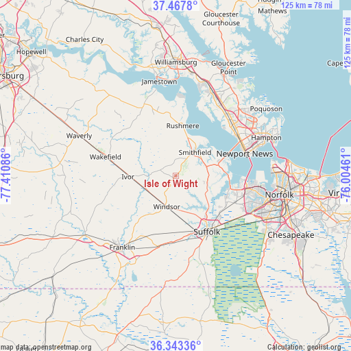
Isle of Wight GPS coordinates[2]
36° 54' 27.54" North, 76° 42' 27.828" West
| Map corner | latitude | longitude |
|---|---|---|
| Upper-left | 37.4678°, | -77.41086° |
| Center: | 36.90765°, | -76.70773° |
| Lower-right: | 36.34336°, | -76.00461° |
| Map W x H: | 125×125 km | = 77.7×77.7mi |
| max Lat: | 71.29058° ⇑66.6% North |
| Isle of Wight: | 36.90765° |
| min Lat: | ⇓33.4% South 19.06759° |
| min Long | Isle of Wight | max Long |
| -171.73463° | -76.70773° | -66.98998° |
| W 81.9%⇐ | ⇒18.1% E |
Elevation
Elevation of Isle of Wight is 21 m = 69 ft, and this is 273.8 m = 898 ft below average elevation for this country.
| Max E: |
3189 m = 10463 ft | 87.8% |
| Avg. | 294.8 m = 967 ft | |
| Isle of Wight | 21 m = 69 ft | |
Min E: |
-60 m = -197 ft | 12.2% |
See also: United States elevation on elevation.city.
Geographical zone
Isle of Wight is located in North temperate zone (between Tropic of Cancer and the Arctic Circle). Distance of this Northern Tropic circle is 1497.8 km =930.7 mi to South.| Distance of | km | miles | from Isle of Wight |
|---|---|---|---|
| North Pole | 5903.3 | 3668.1 | to North |
| Arctic Circle | 3297.4 | 2048.9 | to North |
| Tropic Cancer | 1497.8 | 930.7 | to South |
| Equator | 4103.7 | 2549.9 | to South |


Nearby cities:
15 places around Isle of Wight: (largest is in red/bold)
• Benns Church
11.3 km =7 mi,  72°
72°
• Carrollton
13.8 km =8.6 mi, 71°
• East Hampton
36.4 km =22.6 mi, 66°
• Franklin
31.9 km =19.8 mi,  216°
216°
• Hampton
35 km =21.7 mi, 67°
• Newport News
28.8 km =17.9 mi,  47°
47°
• Portsmouth
37.3 km =23.2 mi,  102°
102°
• Portsmouth Heights
31.7 km =19.7 mi,  107°
107°
• Rushmere
17.9 km =11.1 mi,  8°
8°
• Smithfield
10.7 km =6.6 mi,  39°
39°
• South Suffolk
23.6 km =14.7 mi,  153°
153°
• Suffolk
22.7 km =14.1 mi, 151°
• Surry
28 km =17.4 mi,  336°
336°
• Wakefield
25.9 km =16.1 mi,  285°
285°
• Windsor
11.5 km =7.1 mi,  196°
196°
Sources, notices
• [Note1] Compared only with cities in United States existing in our database
• [Src1] Map data: © OpenStreetMap contributors (CC-BY-SA)
• [Src2] Other city data from geonames.org with taken over terms of usage.
• [Src3] Geographical zone / Annual Mean Temperature by Robert A. Rohde @ Wikipedia
