Tuckahoe geodata
Tuckahoe (Virginia) is a populated place; located in United States in America/New_York (GMT-4) time zone. With population of 44,990 people, there are 1058 cities with bigger population in this country. Compared to other cities in United States, 63.7% of cities are located further ↑North; 78.8% of cities are located further ←West and 73.5% of cities have higher elevation than Tuckahoe. Note1


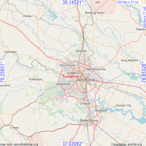
Tuckahoe GPS coordinates[2]
37° 35' 24.54" North, 77° 33' 22.968" West
| Map corner | latitude | longitude |
|---|---|---|
| Upper-left | 38.14521°, | -78.25951° |
| Center: | 37.59015°, | -77.55638° |
| Lower-right: | 37.03092°, | -76.85326° |
| Map W x H: | 123.9×123.9 km | = 77×77mi |
| max Lat: | 71.29058° ⇑63.7% North |
| Tuckahoe: | 37.59015° |
| min Lat: | ⇓36.3% South 19.06759° |
| min Long | Tuckahoe | max Long |
| -171.73463° | -77.55638° | -66.98998° |
| W 78.8%⇐ | ⇒21.2% E |
Elevation
Elevation of Tuckahoe is 80 m = 262 ft, and this is 214.8 m = 705 ft below average elevation for this country.
| Max E: |
3189 m = 10463 ft | 73.5% |
| Avg. | 294.8 m = 967 ft | |
| Tuckahoe | 80 m = 262 ft | |
Min E: |
-60 m = -197 ft | 26.5% |
See also: Tuckahoe elevation on elevation.city.
Geographical zone
Tuckahoe is located in North temperate zone (between Tropic of Cancer and the Arctic Circle). Distance of this Northern Tropic circle is 1573.7 km =977.9 mi to South.| Distance of | km | miles | from Tuckahoe |
|---|---|---|---|
| North Pole | 5827.4 | 3621 | to North |
| Arctic Circle | 3221.5 | 2001.7 | to North |
| Tropic Cancer | 1573.7 | 977.9 | to South |
| Equator | 4179.6 | 2597.1 | to South |


Nearby cities:
15 places around Tuckahoe: (largest is in red/bold)
• Bensley
18.8 km =11.7 mi,  147°
147°
• Bon Air
7.3 km =4.5 mi,  180°
180°
• Chamberlayne
12 km =7.5 mi,  70°
70°
• Dumbarton
5.9 km =3.7 mi,  75°
75°
• East Highland Park
13.2 km =8.2 mi,  94°
94°
• Glen Allen
9.5 km =5.9 mi,  27°
27°
• Lakeside
7.3 km =4.5 mi, 74°
• Laurel
7.2 km =4.5 mi,  35°
35°
• Laurel Park
7.7 km =4.8 mi, 40°
• Meadowbrook
17.3 km =10.7 mi,  155°
155°
• Mechanicsville
16.3 km =10.1 mi, 82°
• Montrose
17.5 km =10.9 mi,  116°
116°
• Richmond
9.4 km =5.8 mi, 115°
• Short Pump
8.3 km =5.2 mi,  323°
323°
• Wyndham
13 km =8.1 mi,  337°
337°
Sources, notices
• [Note1] Compared only with cities in United States existing in our database
• [Src1] Map data: © OpenStreetMap contributors (CC-BY-SA)
• [Src2] Other city data from geonames.org with taken over terms of usage.
• [Src3] Geographical zone / Annual Mean Temperature by Robert A. Rohde @ Wikipedia
