Laurel geodata
Laurel (Virginia) is a populated place; located in United States in America/New_York (GMT-4) time zone. With population of 16,713 people, there are 2939 cities with bigger population in this country. Compared to other cities in United States, 63.5% of cities are located further ↑North; 78.9% of cities are located further ←West and 74.9% of cities have higher elevation than Laurel. Note1


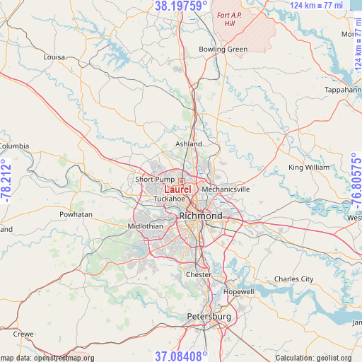
Laurel GPS coordinates[2]
37° 38' 34.512" North, 77° 30' 31.932" West
| Map corner | latitude | longitude |
|---|---|---|
| Upper-left | 38.19759°, | -78.212° |
| Center: | 37.64292°, | -77.50887° |
| Lower-right: | 37.08408°, | -76.80575° |
| Map W x H: | 123.8×123.8 km | = 76.9×76.9mi |
| max Lat: | 71.29058° ⇑63.5% North |
| Laurel: | 37.64292° |
| min Lat: | ⇓36.5% South 19.06759° |
| min Long | Laurel | max Long |
| -171.73463° | -77.50887° | -66.98998° |
| W 78.9%⇐ | ⇒21.1% E |
Elevation
Elevation of Laurel is 72 m = 236 ft, and this is 222.8 m = 731 ft below average elevation for this country.
| Max E: |
3189 m = 10463 ft | 74.9% |
| Avg. | 294.8 m = 967 ft | |
| Laurel | 72 m = 236 ft | |
Min E: |
-60 m = -197 ft | 25.1% |
See also: United States elevation on elevation.city.
Geographical zone
Laurel is located in North temperate zone (between Tropic of Cancer and the Arctic Circle). Distance of this Northern Tropic circle is 1579.6 km =981.5 mi to South.| Distance of | km | miles | from Laurel |
|---|---|---|---|
| North Pole | 5821.6 | 3617.4 | to North |
| Arctic Circle | 3215.7 | 1998.1 | to North |
| Tropic Cancer | 1579.6 | 981.5 | to South |
| Equator | 4185.5 | 2600.7 | to South |


Nearby cities:
15 places around Laurel: (largest is in red/bold)
• Ashland
13.2 km =8.2 mi,  11°
11°
• Bon Air
13.8 km =8.6 mi,  198°
198°
• Chamberlayne
7.3 km =4.5 mi,  104°
104°
• Dumbarton
4.6 km =2.9 mi,  160°
160°
• East Highland Park
11.3 km =7 mi,  127°
127°
• Glen Allen
2.6 km =1.6 mi,  4°
4°
• Hanover
18.4 km =11.4 mi,  41°
41°
• Lakeside
4.8 km =3 mi,  144°
144°
• Laurel Park
0.8 km =0.5 mi,  87°
87°
• Mechanicsville
12.5 km =7.8 mi,  107°
107°
• Montrose
17.8 km =11.1 mi, 139°
• Richmond
10.8 km =6.7 mi, 156°
• Short Pump
9.2 km =5.7 mi,  275°
275°
• Tuckahoe
7.2 km =4.5 mi,  215°
215°
• Wyndham
11 km =6.8 mi,  304°
304°
Sources, notices
• [Note1] Compared only with cities in United States existing in our database
• [Src1] Map data: © OpenStreetMap contributors (CC-BY-SA)
• [Src2] Other city data from geonames.org with taken over terms of usage.
• [Src3] Geographical zone / Annual Mean Temperature by Robert A. Rohde @ Wikipedia
