Bethlehem geodata
Bethlehem (West Virginia) is a populated place; located in United States in America/New_York (GMT-4) time zone. With population of 2,588 people, there are 10423 cities with bigger population in this country. Compared to other cities in United States, 51.6% of cities are located further ↑North; 71.8% of cities are located further ←West and 71.3% of cities have lower elevation than Bethlehem. Note1


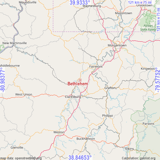
Bethlehem GPS coordinates[2]
39° 23' 31.308" North, 80° 16' 50.304" West
| Map corner | latitude | longitude |
|---|---|---|
| Upper-left | 39.9333°, | -80.98377° |
| Center: | 39.39203°, | -80.28064° |
| Lower-right: | 38.84653°, | -79.57752° |
| Map W x H: | 120.8×120.8 km | = 75.1×75.1mi |
| max Lat: | 71.29058° ⇑51.6% North |
| Bethlehem: | 39.39203° |
| min Lat: | ⇓48.4% South 19.06759° |
| min Long | Bethlehem | max Long |
| -171.73463° | -80.28064° | -66.98998° |
| W 71.8%⇐ | ⇒28.2% E |
Elevation
Elevation of Bethlehem is 292 m = 958 ft, and this is 2.8 m = 9 ft below average elevation for this country.
| Max E: |
3189 m = 10463 ft | 28.7% |
| Avg. | 294.8 m = 967 ft | |
| Bethlehem | 292 m = 958 ft | |
Min E: |
-60 m = -197 ft | 71.3% |
See also: United States elevation on elevation.city.
Geographical zone
Bethlehem is located in North temperate zone (between Tropic of Cancer and the Arctic Circle). Distance of this Northern Tropic circle is 1774.1 km =1102.4 mi to South.| Distance of | km | miles | from Bethlehem |
|---|---|---|---|
| North Pole | 5627.1 | 3496.5 | to North |
| Arctic Circle | 3021.2 | 1877.3 | to North |
| Tropic Cancer | 1774.1 | 1102.4 | to South |
| Equator | 4380 | 2721.6 | to South |


Nearby cities:
15 places around Bethlehem: (largest is in red/bold)
• Anmoore
15.1 km =9.4 mi,  183°
183°
• Barrackville
15.8 km =9.8 mi,  38°
38°
• Bridgeport
11.9 km =7.4 mi,  169°
169°
• Clarksburg
13.5 km =8.4 mi,  203°
203°
• Despard
11.7 km =7.3 mi,  190°
190°
• Enterprise
3.2 km =2 mi,  4°
4°
• Fairmont
15.7 km =9.8 mi,  48°
48°
• Hepzibah
8.1 km =5 mi,  215°
215°
• Idamay
11.8 km =7.3 mi,  9°
9°
• Lumberport
6.2 km =3.9 mi,  250°
250°
• Monongah
9.5 km =5.9 mi,  34°
34°
• Nutter Fort
14.7 km =9.1 mi, 193°
• Pleasant Valley
13.9 km =8.6 mi,  59°
59°
• Shinnston
1.7 km =1.1 mi,  283°
283°
• White Hall
9 km =5.6 mi,  68°
68°
Sources, notices
• [Note1] Compared only with cities in United States existing in our database
• [Src1] Map data: © OpenStreetMap contributors (CC-BY-SA)
• [Src2] Other city data from geonames.org with taken over terms of usage.
• [Src3] Geographical zone / Annual Mean Temperature by Robert A. Rohde @ Wikipedia
