Clarksburg geodata
Clarksburg (West Virginia) is a seat of a second-order administrative division; located in United States in America/New_York (GMT-4) time zone. With population of 16,152 people, there are 3035 cities with bigger population in this country. Compared to other cities in United States, 52.4% of cities are located further ↑North; 71.5% of cities are located further ←West and 73.8% of cities have lower elevation than Clarksburg. Note1


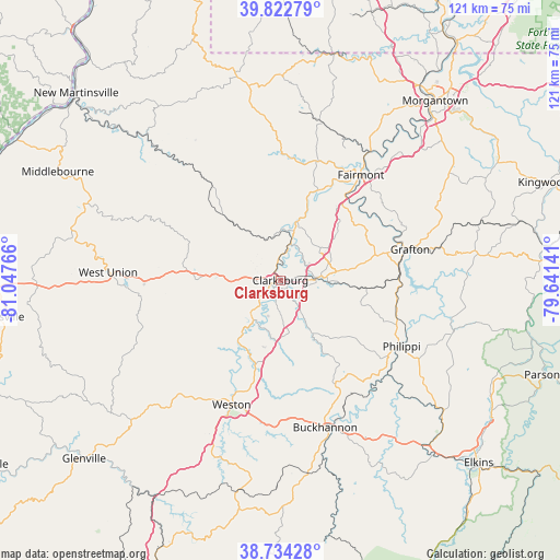
Clarksburg GPS coordinates[2]
39° 16' 50.34" North, 80° 20' 40.308" West
| Map corner | latitude | longitude |
|---|---|---|
| Upper-left | 39.82279°, | -81.04766° |
| Center: | 39.28065°, | -80.34453° |
| Lower-right: | 38.73428°, | -79.64141° |
| Map W x H: | 121×121 km | = 75.2×75.2mi |
| max Lat: | 71.29058° ⇑52.4% North |
| Clarksburg: | 39.28065° |
| min Lat: | ⇓47.6% South 19.06759° |
| min Long | Clarksburg | max Long |
| -171.73463° | -80.34453° | -66.98998° |
| W 71.5%⇐ | ⇒28.5% E |
Elevation
Elevation of Clarksburg is 306 m = 1004 ft, and this is 11.2 m = 37 ft above average elevation for this country.
| Max E: |
3189 m = 10463 ft | 26.2% |
| Clarksburg | 306 m 1004 ft | |
| Avg. | 294.8 m = 967 ft | |
Min E: |
-60 m = -197 ft | 73.8% |
See also: United States elevation on elevation.city.
Geographical zone
Clarksburg is located in North temperate zone (between Tropic of Cancer and the Arctic Circle). Distance of this Northern Tropic circle is 1761.7 km =1094.7 mi to South.| Distance of | km | miles | from Clarksburg |
|---|---|---|---|
| North Pole | 5639.5 | 3504.2 | to North |
| Arctic Circle | 3033.6 | 1885 | to North |
| Tropic Cancer | 1761.7 | 1094.7 | to South |
| Equator | 4367.6 | 2713.9 | to South |


Nearby cities:
15 places around Clarksburg: (largest is in red/bold)
• Anmoore
5.2 km =3.2 mi,  120°
120°
• Bethlehem
13.5 km =8.4 mi,  23°
23°
• Bridgeport
7.6 km =4.7 mi,  85°
85°
• Despard
3.4 km =2.1 mi,  74°
74°
• Enterprise
16.6 km =10.3 mi, 20°
• Hepzibah
5.8 km =3.6 mi,  7°
7°
• Idamay
25.2 km =15.7 mi, 17°
• Lumberport
10.4 km =6.5 mi,  358°
358°
• Monongah
23 km =14.3 mi,  28°
28°
• Nutter Fort
2.9 km =1.8 mi,  131°
131°
• Salem
18.5 km =11.5 mi,  270°
270°
• Shinnston
13.3 km =8.3 mi, 16°
• Stonewood
4.3 km =2.7 mi,  140°
140°
• West Milford
10.2 km =6.3 mi,  210°
210°
• White Hall
20.9 km =13 mi,  41°
41°
Sources, notices
• [Note1] Compared only with cities in United States existing in our database
• [Src1] Map data: © OpenStreetMap contributors (CC-BY-SA)
• [Src2] Other city data from geonames.org with taken over terms of usage.
• [Src3] Geographical zone / Annual Mean Temperature by Robert A. Rohde @ Wikipedia
