Bolivar geodata
Bolivar (West Virginia) is a populated place; located in United States in America/New_York (GMT-4) time zone. With population of 1,060 people, there are 15901 cities with bigger population in this country. Compared to other cities in United States, 52.1% of cities are located further ↑North; 78.3% of cities are located further ←West and 60.7% of cities have higher elevation than Bolivar. Note1


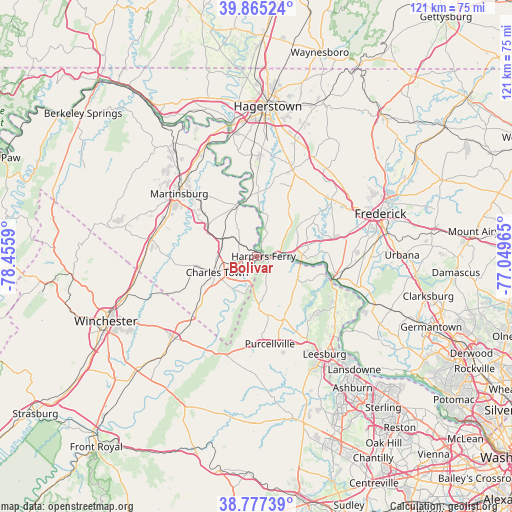
Bolivar GPS coordinates[2]
39° 19' 24.348" North, 77° 45' 9.972" West
| Map corner | latitude | longitude |
|---|---|---|
| Upper-left | 39.86524°, | -78.4559° |
| Center: | 39.32343°, | -77.75277° |
| Lower-right: | 38.77739°, | -77.04965° |
| Map W x H: | 121×121 km | = 75.2×75.2mi |
| max Lat: | 71.29058° ⇑52.1% North |
| Bolivar: | 39.32343° |
| min Lat: | ⇓47.9% South 19.06759° |
| min Long | Bolivar | max Long |
| -171.73463° | -77.75277° | -66.98998° |
| W 78.3%⇐ | ⇒21.7% E |
Elevation
Elevation of Bolivar is 151 m = 495 ft, and this is 143.8 m = 472 ft below average elevation for this country.
| Max E: |
3189 m = 10463 ft | 60.7% |
| Avg. | 294.8 m = 967 ft | |
| Bolivar | 151 m = 495 ft | |
Min E: |
-60 m = -197 ft | 39.3% |
See also: United States elevation on elevation.city.
Geographical zone
Bolivar is located in North temperate zone (between Tropic of Cancer and the Arctic Circle). Distance of this Northern Tropic circle is 1766.4 km =1097.6 mi to South.| Distance of | km | miles | from Bolivar |
|---|---|---|---|
| North Pole | 5634.7 | 3501.2 | to North |
| Arctic Circle | 3028.8 | 1882 | to North |
| Tropic Cancer | 1766.4 | 1097.6 | to South |
| Equator | 4372.4 | 2716.9 | to South |


Nearby cities:
15 places around Bolivar: (largest is in red/bold)
• Boonsboro
22.1 km =13.7 mi,  22°
22°
• Brunswick
10.8 km =6.7 mi,  95°
95°
• Charles Town
10 km =6.2 mi,  247°
247°
• Jefferson
19.5 km =12.1 mi,  77°
77°
• Keedysville
18.7 km =11.6 mi,  14°
14°
• Lovettsville
11.5 km =7.1 mi,  119°
119°
• Middletown
22.3 km =13.9 mi,  53°
53°
• Point of Rocks
19.1 km =11.9 mi,  106°
106°
• Purcellville
21 km =13 mi,  171°
171°
• Ranson
9.8 km =6.1 mi, 251°
• Round Hill
21.3 km =13.2 mi,  183°
183°
• Shannondale
12.7 km =7.9 mi,  201°
201°
• Sharpsburg
14.9 km =9.3 mi,  1°
1°
• Shenandoah Junction
8.7 km =5.4 mi,  296°
296°
• Shepherdstown
12.7 km =7.9 mi,  339°
339°
Sources, notices
• [Note1] Compared only with cities in United States existing in our database
• [Src1] Map data: © OpenStreetMap contributors (CC-BY-SA)
• [Src2] Other city data from geonames.org with taken over terms of usage.
• [Src3] Geographical zone / Annual Mean Temperature by Robert A. Rohde @ Wikipedia
