Purcellville geodata
Purcellville (Virginia) is a populated place; located in United States in America/New_York (GMT-4) time zone. With population of 9,232 people, there are 4718 cities with bigger population in this country. Compared to other cities in United States, 53.6% of cities are located further ↑North; 78.4% of cities are located further ←West and 56.8% of cities have higher elevation than Purcellville. Note1


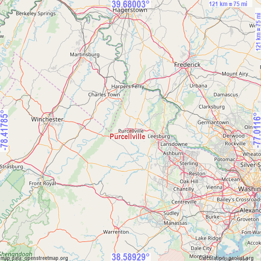
Purcellville GPS coordinates[2]
39° 8' 12.372" North, 77° 42' 52.992" West
| Map corner | latitude | longitude |
|---|---|---|
| Upper-left | 39.68003°, | -78.41785° |
| Center: | 39.13677°, | -77.71472° |
| Lower-right: | 38.58929°, | -77.0116° |
| Map W x H: | 121.3×121.3 km | = 75.4×75.4mi |
| max Lat: | 71.29058° ⇑53.6% North |
| Purcellville: | 39.13677° |
| min Lat: | ⇓46.4% South 19.06759° |
| min Long | Purcellville | max Long |
| -171.73463° | -77.71472° | -66.98998° |
| W 78.4%⇐ | ⇒21.6% E |
Elevation
Elevation of Purcellville is 172 m = 564 ft, and this is 122.8 m = 403 ft below average elevation for this country.
| Max E: |
3189 m = 10463 ft | 56.8% |
| Avg. | 294.8 m = 967 ft | |
| Purcellville | 172 m = 564 ft | |
Min E: |
-60 m = -197 ft | 43.2% |
See also: United States elevation on elevation.city.
Geographical zone
Purcellville is located in North temperate zone (between Tropic of Cancer and the Arctic Circle). Distance of this Northern Tropic circle is 1745.7 km =1084.7 mi to South.| Distance of | km | miles | from Purcellville |
|---|---|---|---|
| North Pole | 5655.5 | 3514.2 | to North |
| Arctic Circle | 3049.6 | 1894.9 | to North |
| Tropic Cancer | 1745.7 | 1084.7 | to South |
| Equator | 4351.6 | 2704 | to South |


Nearby cities:
15 places around Purcellville: (largest is in red/bold)
• Ashburn
22.2 km =13.8 mi,  117°
117°
• Belmont
19.4 km =12.1 mi,  114°
114°
• Bolivar
21 km =13 mi,  351°
351°
• Broadlands
21.3 km =13.2 mi,  128°
128°
• Brunswick
21.1 km =13.1 mi,  20°
20°
• Charles Town
21 km =13 mi,  323°
323°
• Hamilton
4.5 km =2.8 mi,  93°
93°
• Leesburg
13.2 km =8.2 mi,  100°
100°
• Lovettsville
16.5 km =10.3 mi, 24°
• Middleburg
18.8 km =11.7 mi,  185°
185°
• Point of Rocks
21.6 km =13.4 mi,  44°
44°
• Ranson
21.6 km =13.4 mi, 324°
• Round Hill
4.7 km =2.9 mi,  264°
264°
• Shannondale
12 km =7.5 mi, 318°
• Shenandoah Retreat
13 km =8.1 mi,  268°
268°
Sources, notices
• [Note1] Compared only with cities in United States existing in our database
• [Src1] Map data: © OpenStreetMap contributors (CC-BY-SA)
• [Src2] Other city data from geonames.org with taken over terms of usage.
• [Src3] Geographical zone / Annual Mean Temperature by Robert A. Rohde @ Wikipedia
