Lavalette geodata
Lavalette (West Virginia) is a populated place; located in United States in America/New_York (GMT-4) time zone. With population of 1,073 people, there are 15830 cities with bigger population in this country. Compared to other cities in United States, 59.8% of cities are located further ↑North; 64.1% of cities are located further ←West and 56% of cities have higher elevation than Lavalette. Note1


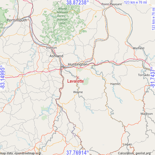
Lavalette GPS coordinates[2]
38° 19' 22.296" North, 82° 26' 48.552" West
| Map corner | latitude | longitude |
|---|---|---|
| Upper-left | 38.87238°, | -83.14995° |
| Center: | 38.32286°, | -82.44682° |
| Lower-right: | 37.76914°, | -81.7437° |
| Map W x H: | 122.7×122.7 km | = 76.2×76.2mi |
| max Lat: | 71.29058° ⇑59.8% North |
| Lavalette: | 38.32286° |
| min Lat: | ⇓40.2% South 19.06759° |
| min Long | Lavalette | max Long |
| -171.73463° | -82.44682° | -66.98998° |
| W 64.1%⇐ | ⇒35.9% E |
Elevation
Elevation of Lavalette is 176 m = 577 ft, and this is 118.8 m = 390 ft below average elevation for this country.
| Max E: |
3189 m = 10463 ft | 56% |
| Avg. | 294.8 m = 967 ft | |
| Lavalette | 176 m = 577 ft | |
Min E: |
-60 m = -197 ft | 44% |
See also: United States elevation on elevation.city.
Geographical zone
Lavalette is located in North temperate zone (between Tropic of Cancer and the Arctic Circle). Distance of this Northern Tropic circle is 1655.2 km =1028.5 mi to South.| Distance of | km | miles | from Lavalette |
|---|---|---|---|
| North Pole | 5746 | 3570.4 | to North |
| Arctic Circle | 3140.1 | 1951.2 | to North |
| Tropic Cancer | 1655.2 | 1028.5 | to South |
| Equator | 4261.1 | 2647.7 | to South |


Nearby cities:
15 places around Lavalette: (largest is in red/bold)
• Ashland
24 km =14.9 mi,  316°
316°
• Barboursville
16.4 km =10.2 mi,  54°
54°
• Burlington
12.2 km =7.6 mi, 320°
• Cannonsburg
23.5 km =14.6 mi,  288°
288°
• Catlettsburg
16.2 km =10.1 mi,  304°
304°
• Ceredo
12.7 km =7.9 mi,  309°
309°
• Chesapeake
11.7 km =7.3 mi,  355°
355°
• Huntington
10.7 km =6.6 mi,  0°
0°
• Kenova
14.2 km =8.8 mi, 306°
• Pea Ridge
15 km =9.3 mi, 47°
• Prichard
16.1 km =10 mi,  235°
235°
• Proctorville
14.1 km =8.8 mi,  25°
25°
• South Point
16.1 km =10 mi, 310°
• Wayne
11.3 km =7 mi,  178°
178°
• West Hamlin
22.3 km =13.9 mi,  100°
100°
Sources, notices
• [Note1] Compared only with cities in United States existing in our database
• [Src1] Map data: © OpenStreetMap contributors (CC-BY-SA)
• [Src2] Other city data from geonames.org with taken over terms of usage.
• [Src3] Geographical zone / Annual Mean Temperature by Robert A. Rohde @ Wikipedia
