Wayne geodata
Wayne (West Virginia) is a seat of a second-order administrative division; located in United States in America/New_York (GMT-4) time zone. With population of 1,382 people, there are 14197 cities with bigger population in this country. Compared to other cities in United States, 60.5% of cities are located further ↑North; 64.1% of cities are located further ←West and 53.9% of cities have lower elevation than Wayne. Note1


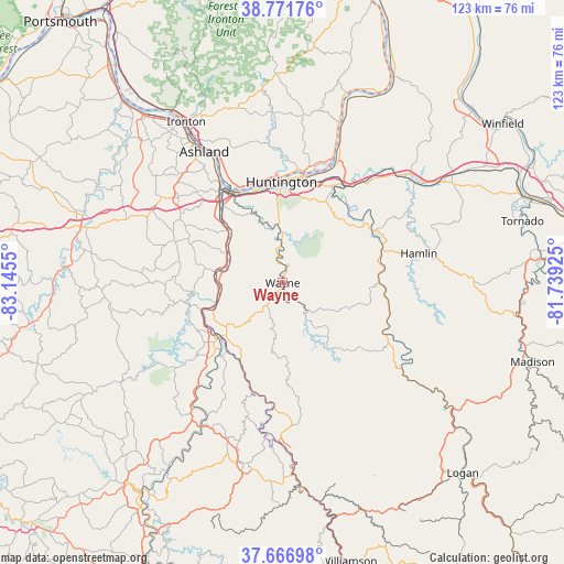
Wayne GPS coordinates[2]
38° 13' 17.292" North, 82° 26' 32.532" West
| Map corner | latitude | longitude |
|---|---|---|
| Upper-left | 38.77176°, | -83.1455° |
| Center: | 38.22147°, | -82.44237° |
| Lower-right: | 37.66698°, | -81.73925° |
| Map W x H: | 122.8×122.8 km | = 76.3×76.3mi |
| max Lat: | 71.29058° ⇑60.5% North |
| Wayne: | 38.22147° |
| min Lat: | ⇓39.5% South 19.06759° |
| min Long | Wayne | max Long |
| -171.73463° | -82.44237° | -66.98998° |
| W 64.1%⇐ | ⇒35.9% E |
Elevation
Elevation of Wayne is 214 m = 702 ft, and this is 80.8 m = 265 ft below average elevation for this country.
| Max E: |
3189 m = 10463 ft | 46.1% |
| Avg. | 294.8 m = 967 ft | |
| Wayne | 214 m = 702 ft | |
Min E: |
-60 m = -197 ft | 53.9% |
See also: United States elevation on elevation.city.
Geographical zone
Wayne is located in North temperate zone (between Tropic of Cancer and the Arctic Circle). Distance of this Northern Tropic circle is 1643.9 km =1021.5 mi to South.| Distance of | km | miles | from Wayne |
|---|---|---|---|
| North Pole | 5757.2 | 3577.4 | to North |
| Arctic Circle | 3151.3 | 1958.1 | to North |
| Tropic Cancer | 1643.9 | 1021.5 | to South |
| Equator | 4249.8 | 2640.7 | to South |


Nearby cities:
15 places around Wayne: (largest is in red/bold)
• Barboursville
24.6 km =15.3 mi,  31°
31°
• Burlington
22.2 km =13.8 mi,  338°
338°
• Catlettsburg
24.6 km =15.3 mi,  325°
325°
• Ceredo
21.9 km =13.6 mi, 332°
• Chesapeake
23 km =14.3 mi,  356°
356°
• Fort Gay
17.8 km =11.1 mi,  228°
228°
• Huntington
22 km =13.7 mi, 359°
• Kenova
23 km =14.3 mi, 329°
• Lavalette
11.3 km =7 mi, 358°
• Louisa
18.4 km =11.4 mi, 229°
• Pea Ridge
23.9 km =14.9 mi, 26°
• Prichard
13.8 km =8.6 mi,  278°
278°
• Proctorville
24.6 km =15.3 mi,  13°
13°
• South Point
25.2 km =15.7 mi, 330°
• West Hamlin
22.7 km =14.1 mi,  71°
71°
Sources, notices
• [Note1] Compared only with cities in United States existing in our database
• [Src1] Map data: © OpenStreetMap contributors (CC-BY-SA)
• [Src2] Other city data from geonames.org with taken over terms of usage.
• [Src3] Geographical zone / Annual Mean Temperature by Robert A. Rohde @ Wikipedia
