Milton geodata
Milton (West Virginia) is a populated place; located in United States in America/New_York (GMT-4) time zone. With population of 2,637 people, there are 10317 cities with bigger population in this country. Compared to other cities in United States, 59.1% of cities are located further ↑North; 65.1% of cities are located further ←West and 55.5% of cities have higher elevation than Milton. Note1


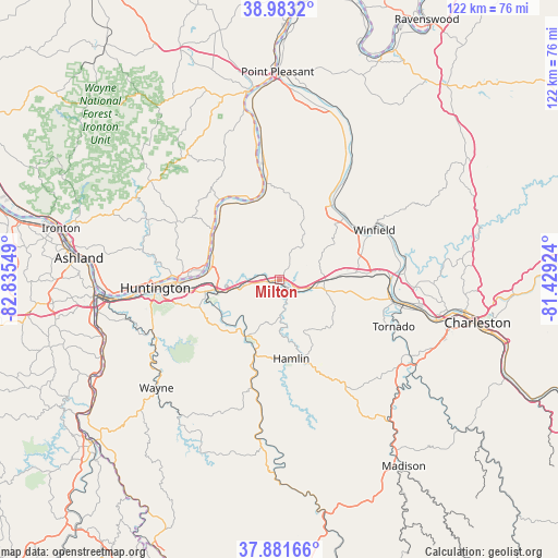
Milton GPS coordinates[2]
38° 26' 4.308" North, 82° 7' 56.496" West
| Map corner | latitude | longitude |
|---|---|---|
| Upper-left | 38.9832°, | -82.83549° |
| Center: | 38.43453°, | -82.13236° |
| Lower-right: | 37.88166°, | -81.42924° |
| Map W x H: | 122.5×122.5 km | = 76.1×76.1mi |
| max Lat: | 71.29058° ⇑59.1% North |
| Milton: | 38.43453° |
| min Lat: | ⇓40.9% South 19.06759° |
| min Long | Milton | max Long |
| -171.73463° | -82.13236° | -66.98998° |
| W 65.1%⇐ | ⇒34.9% E |
Elevation
Elevation of Milton is 178 m = 584 ft, and this is 116.8 m = 383 ft below average elevation for this country.
| Max E: |
3189 m = 10463 ft | 55.5% |
| Avg. | 294.8 m = 967 ft | |
| Milton | 178 m = 584 ft | |
Min E: |
-60 m = -197 ft | 44.5% |
See also: United States elevation on elevation.city.
Geographical zone
Milton is located in North temperate zone (between Tropic of Cancer and the Arctic Circle). Distance of this Northern Tropic circle is 1667.6 km =1036.2 mi to South.| Distance of | km | miles | from Milton |
|---|---|---|---|
| North Pole | 5733.5 | 3562.6 | to North |
| Arctic Circle | 3127.7 | 1943.5 | to North |
| Tropic Cancer | 1667.6 | 1036.2 | to South |
| Equator | 4273.5 | 2655.4 | to South |


Nearby cities:
15 places around Milton: (largest is in red/bold)
• Barboursville
14.4 km =8.9 mi,  258°
258°
• Buffalo
24.2 km =15 mi,  32°
32°
• Culloden
6.9 km =4.3 mi,  103°
103°
• Eleanor
20.8 km =12.9 mi,  56°
56°
• Hamlin
17.5 km =10.9 mi,  171°
171°
• Hometown
26 km =16.2 mi,  65°
65°
• Hurricane
9.8 km =6.1 mi,  91°
91°
• Lesage
16.5 km =10.3 mi,  298°
298°
• Nitro
25.2 km =15.7 mi, 94°
• Pea Ridge
16.5 km =10.3 mi, 262°
• Proctorville
21.3 km =13.2 mi,  270°
270°
• Saint Albans
26.4 km =16.4 mi, 101°
• Teays Valley
17.8 km =11.1 mi,  84°
84°
• West Hamlin
17.5 km =10.9 mi,  198°
198°
• Winfield
23.5 km =14.6 mi, 62°
Sources, notices
• [Note1] Compared only with cities in United States existing in our database
• [Src1] Map data: © OpenStreetMap contributors (CC-BY-SA)
• [Src2] Other city data from geonames.org with taken over terms of usage.
• [Src3] Geographical zone / Annual Mean Temperature by Robert A. Rohde @ Wikipedia
