Mineral Wells geodata
Mineral Wells (West Virginia) is a populated place; located in United States in America/New_York (GMT-4) time zone. With population of 1,950 people, there are 12096 cities with bigger population in this country. Compared to other cities in United States, 53.2% of cities are located further ↑North; 67.4% of cities are located further ←West and 50.3% of cities have higher elevation than Mineral Wells. Note1


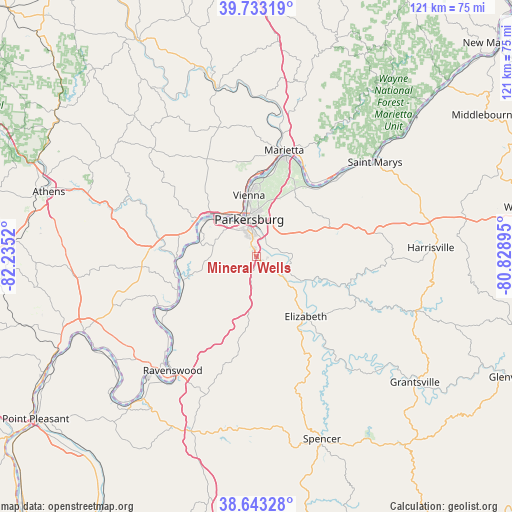
Mineral Wells GPS coordinates[2]
39° 11' 25.26" North, 81° 31' 55.452" West
| Map corner | latitude | longitude |
|---|---|---|
| Upper-left | 39.73319°, | -82.2352° |
| Center: | 39.19035°, | -81.53207° |
| Lower-right: | 38.64328°, | -80.82895° |
| Map W x H: | 121.2×121.2 km | = 75.3×75.3mi |
| max Lat: | 71.29058° ⇑53.2% North |
| Mineral Wells: | 39.19035° |
| min Lat: | ⇓46.8% South 19.06759° |
| min Long | Mineral Wells | max Long |
| -171.73463° | -81.53207° | -66.98998° |
| W 67.4%⇐ | ⇒32.6% E |
Elevation
Elevation of Mineral Wells is 197 m = 646 ft, and this is 97.8 m = 321 ft below average elevation for this country.
| Max E: |
3189 m = 10463 ft | 50.3% |
| Avg. | 294.8 m = 967 ft | |
| Mineral Wells | 197 m = 646 ft | |
Min E: |
-60 m = -197 ft | 49.7% |
See also: United States elevation on elevation.city.
Geographical zone
Mineral Wells is located in North temperate zone (between Tropic of Cancer and the Arctic Circle). Distance of this Northern Tropic circle is 1751.6 km =1088.4 mi to South.| Distance of | km | miles | from Mineral Wells |
|---|---|---|---|
| North Pole | 5649.5 | 3510.4 | to North |
| Arctic Circle | 3043.6 | 1891.2 | to North |
| Tropic Cancer | 1751.6 | 1088.4 | to South |
| Equator | 4357.6 | 2707.7 | to South |


Nearby cities:
15 places around Mineral Wells: (largest is in red/bold)
• Belmont
31.6 km =19.6 mi,  48°
48°
• Belpre
9.9 km =6.2 mi,  339°
339°
• Blennerhassett
11.7 km =7.3 mi,  314°
314°
• Boaz
19.2 km =11.9 mi,  7°
7°
• Devola
31.8 km =19.8 mi, 8°
• Elizabeth
18.4 km =11.4 mi,  140°
140°
• Lubeck
9.9 km =6.2 mi,  300°
300°
• Marietta
25.9 km =16.1 mi, 14°
• North Hills
14.1 km =8.8 mi, 6°
• Parkersburg
8.9 km =5.5 mi, 343°
• Ravenswood
33.4 km =20.8 mi,  216°
216°
• Reno
23.4 km =14.5 mi,  30°
30°
• Vienna
15.3 km =9.5 mi,  354°
354°
• Washington
14.4 km =8.9 mi, 303°
• Williamstown
24.5 km =15.2 mi,  17°
17°
Sources, notices
• [Note1] Compared only with cities in United States existing in our database
• [Src1] Map data: © OpenStreetMap contributors (CC-BY-SA)
• [Src2] Other city data from geonames.org with taken over terms of usage.
• [Src3] Geographical zone / Annual Mean Temperature by Robert A. Rohde @ Wikipedia
