Romney geodata
Romney (West Virginia) is a seat of a second-order administrative division; located in United States in America/New_York (GMT-4) time zone. With population of 1,773 people, there are 12655 cities with bigger population in this country. Compared to other cities in United States, 51.9% of cities are located further ↑North; 76.4% of cities are located further ←West and 62.4% of cities have lower elevation than Romney. Note1


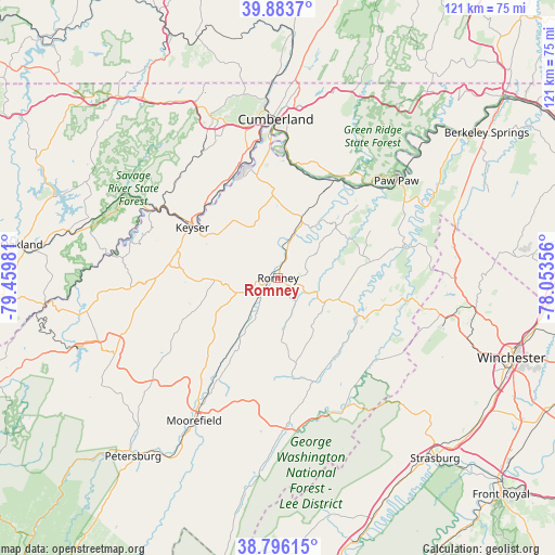
Romney GPS coordinates[2]
39° 20' 31.344" North, 78° 45' 24.048" West
| Map corner | latitude | longitude |
|---|---|---|
| Upper-left | 39.8837°, | -79.45981° |
| Center: | 39.34204°, | -78.75668° |
| Lower-right: | 38.79615°, | -78.05356° |
| Map W x H: | 120.9×120.9 km | = 75.1×75.1mi |
| max Lat: | 71.29058° ⇑51.9% North |
| Romney: | 39.34204° |
| min Lat: | ⇓48.1% South 19.06759° |
| min Long | Romney | max Long |
| -171.73463° | -78.75668° | -66.98998° |
| W 76.4%⇐ | ⇒23.6% E |
Elevation
Elevation of Romney is 250 m = 820 ft, and this is 44.8 m = 147 ft below average elevation for this country.
| Max E: |
3189 m = 10463 ft | 37.6% |
| Avg. | 294.8 m = 967 ft | |
| Romney | 250 m = 820 ft | |
Min E: |
-60 m = -197 ft | 62.4% |
See also: United States elevation on elevation.city.
Geographical zone
Romney is located in North temperate zone (between Tropic of Cancer and the Arctic Circle). Distance of this Northern Tropic circle is 1768.5 km =1098.9 mi to South.| Distance of | km | miles | from Romney |
|---|---|---|---|
| North Pole | 5632.6 | 3499.9 | to North |
| Arctic Circle | 3026.7 | 1880.7 | to North |
| Tropic Cancer | 1768.5 | 1098.9 | to South |
| Equator | 4374.4 | 2718.1 | to South |


Nearby cities:
15 places around Romney: (largest is in red/bold)
• Bel Air
26.9 km =16.7 mi,  342°
342°
• Bowling Green
31.6 km =19.6 mi,  352°
352°
• Carpendale
32.5 km =20.2 mi,  355°
355°
• Cresaptown
28.7 km =17.8 mi, 346°
• Fort Ashby
17.9 km =11.1 mi, 356°
• Keyser
21.7 km =13.5 mi,  300°
300°
• Lonaconing
31.4 km =19.5 mi,  322°
322°
• Maryland Junction
32.4 km =20.1 mi, 355°
• McCoole
21.9 km =13.6 mi, 302°
• Piedmont
29.4 km =18.3 mi, 301°
• Potomac Park
30.3 km =18.8 mi, 351°
• Rawlings
24 km =14.9 mi,  333°
333°
• Ridgeley
33.3 km =20.7 mi, 357°
• Westernport
29.4 km =18.3 mi, 302°
• Wiley Ford
30.3 km =18.8 mi, 357°
Sources, notices
• [Note1] Compared only with cities in United States existing in our database
• [Src1] Map data: © OpenStreetMap contributors (CC-BY-SA)
• [Src2] Other city data from geonames.org with taken over terms of usage.
• [Src3] Geographical zone / Annual Mean Temperature by Robert A. Rohde @ Wikipedia
