Ballplay geodata
Ballplay (Alabama) is a populated place; located in United States in America/Chicago (GMT-5) time zone. With population of 1,580 people, there are 13353 cities with bigger population in this country. Compared to other cities in United States, 79.8% of cities are located further ↑North; 53.4% of cities are located further ←West and 54.5% of cities have higher elevation than Ballplay. Note1


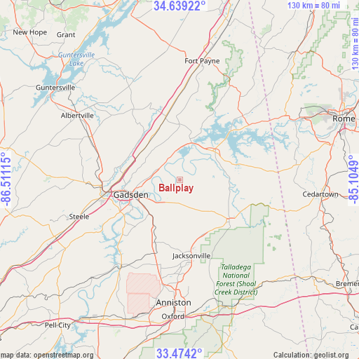
Ballplay GPS coordinates[2]
34° 3' 31.356" North, 85° 48' 28.872" West
| Map corner | latitude | longitude |
|---|---|---|
| Upper-left | 34.63922°, | -86.51115° |
| Center: | 34.05871°, | -85.80802° |
| Lower-right: | 33.4742°, | -85.1049° |
| Map W x H: | 129.5×129.5 km | = 80.5×80.5mi |
| max Lat: | 71.29058° ⇑79.8% North |
| Ballplay: | 34.05871° |
| min Lat: | ⇓20.2% South 19.06759° |
| min Long | Ballplay | max Long |
| -171.73463° | -85.80802° | -66.98998° |
| W 53.4%⇐ | ⇒46.6% E |
Elevation
Elevation of Ballplay is 182 m = 597 ft, and this is 112.8 m = 370 ft below average elevation for this country.
| Max E: |
3189 m = 10463 ft | 54.5% |
| Avg. | 294.8 m = 967 ft | |
| Ballplay | 182 m = 597 ft | |
Min E: |
-60 m = -197 ft | 45.5% |
See also: United States elevation on elevation.city.
Geographical zone
Ballplay is located in North temperate zone (between Tropic of Cancer and the Arctic Circle). Distance of this Northern Tropic circle is 1181.1 km =733.9 mi to South.| Distance of | km | miles | from Ballplay |
|---|---|---|---|
| North Pole | 6220.1 | 3865 | to North |
| Arctic Circle | 3614.2 | 2245.8 | to North |
| Tropic Cancer | 1181.1 | 733.9 | to South |
| Equator | 3787 | 2353.1 | to South |


Nearby cities:
15 places around Ballplay: (largest is in red/bold)
• Attalla
26.2 km =16.3 mi,  260°
260°
• Cedar Bluff
25.7 km =16 mi,  45°
45°
• Centre
15.8 km =9.8 mi, 48°
• Collinsville
23.3 km =14.5 mi,  348°
348°
• Gadsden
18.9 km =11.7 mi,  254°
254°
• Glencoe
16.1 km =10 mi,  225°
225°
• Hokes Bluff
8.6 km =5.3 mi,  218°
218°
• Leesburg
14.1 km =8.8 mi,  17°
17°
• Mount Vernon
26.1 km =16.2 mi,  4°
4°
• Piedmont
23.5 km =14.6 mi,  129°
129°
• Rainbow City
24.5 km =15.2 mi,  241°
241°
• Reece City
20.8 km =12.9 mi,  274°
274°
• Sand Rock
20.8 km =12.9 mi,  10°
10°
• Southside
24.8 km =15.4 mi, 232°
• Whitesboro
26.7 km =16.6 mi,  295°
295°
Sources, notices
• [Note1] Compared only with cities in United States existing in our database
• [Src1] Map data: © OpenStreetMap contributors (CC-BY-SA)
• [Src2] Other city data from geonames.org with taken over terms of usage.
• [Src3] Geographical zone / Annual Mean Temperature by Robert A. Rohde @ Wikipedia
