Sand Rock geodata
Sand Rock (Alabama) is a populated place; located in United States in America/Chicago (GMT-5) time zone. With population of 558 people, there are 20177 cities with bigger population in this country. Compared to other cities in United States, 78.7% of cities are located further ↑North; 53.5% of cities are located further ←West and 69.3% of cities have lower elevation than Sand Rock. Note1


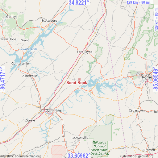
Sand Rock GPS coordinates[2]
34° 14' 34.332" North, 85° 46' 6.888" West
| Map corner | latitude | longitude |
|---|---|---|
| Upper-left | 34.8221°, | -86.47171° |
| Center: | 34.24287°, | -85.76858° |
| Lower-right: | 33.65962°, | -85.06546° |
| Map W x H: | 129.3×129.3 km | = 80.3×80.3mi |
| max Lat: | 71.29058° ⇑78.7% North |
| Sand Rock: | 34.24287° |
| min Lat: | ⇓21.3% South 19.06759° |
| min Long | Sand Rock | max Long |
| -171.73463° | -85.76858° | -66.98998° |
| W 53.5%⇐ | ⇒46.5% E |
Elevation
Elevation of Sand Rock is 282 m = 925 ft, and this is 12.8 m = 42 ft below average elevation for this country.
| Max E: |
3189 m = 10463 ft | 30.7% |
| Avg. | 294.8 m = 967 ft | |
| Sand Rock | 282 m = 925 ft | |
Min E: |
-60 m = -197 ft | 69.3% |
See also: United States elevation on elevation.city.
Geographical zone
Sand Rock is located in North temperate zone (between Tropic of Cancer and the Arctic Circle). Distance of this Northern Tropic circle is 1201.5 km =746.6 mi to South.| Distance of | km | miles | from Sand Rock |
|---|---|---|---|
| North Pole | 6199.6 | 3852.3 | to North |
| Arctic Circle | 3593.7 | 2233 | to North |
| Tropic Cancer | 1201.5 | 746.6 | to South |
| Equator | 3807.5 | 2365.9 | to South |


Nearby cities:
15 places around Sand Rock: (largest is in red/bold)
• Ballplay
20.8 km =12.9 mi,  190°
190°
• Cedar Bluff
15 km =9.3 mi,  99°
99°
• Centre
13 km =8.1 mi,  140°
140°
• Collinsville
8.8 km =5.5 mi,  285°
285°
• Crossville
21.3 km =13.2 mi,  283°
283°
• Fort Payne
22.8 km =14.2 mi,  11°
11°
• Fyffe
25.9 km =16.1 mi,  331°
331°
• Geraldine
24.5 km =15.2 mi,  299°
299°
• Hokes Bluff
28.7 km =17.8 mi,  198°
198°
• Leesburg
7 km =4.3 mi,  174°
174°
• Mount Vernon
5.8 km =3.6 mi,  342°
342°
• Rainsville
28.9 km =18 mi,  345°
345°
• Reece City
30.9 km =19.2 mi,  232°
232°
• Sardis City
33.4 km =20.8 mi,  256°
256°
• Whitesboro
29 km =18 mi,  252°
252°
Sources, notices
• [Note1] Compared only with cities in United States existing in our database
• [Src1] Map data: © OpenStreetMap contributors (CC-BY-SA)
• [Src2] Other city data from geonames.org with taken over terms of usage.
• [Src3] Geographical zone / Annual Mean Temperature by Robert A. Rohde @ Wikipedia
