Cedar Bluff geodata
Cedar Bluff (Alabama) is a populated place; located in United States in America/Chicago (GMT-5) time zone. With population of 1,802 people, there are 12532 cities with bigger population in this country. Compared to other cities in United States, 78.9% of cities are located further ↑North; 54.3% of cities are located further ←West and 55.7% of cities have higher elevation than Cedar Bluff. Note1


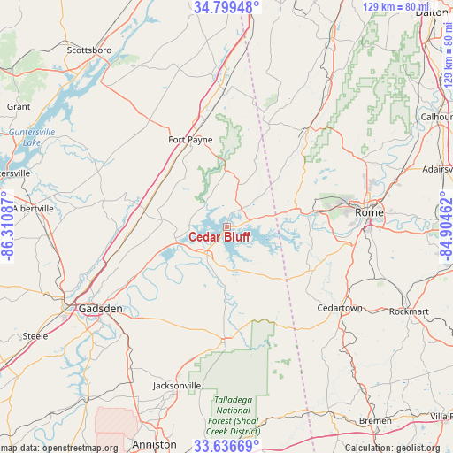
Cedar Bluff GPS coordinates[2]
34° 13' 12.324" North, 85° 36' 27.864" West
| Map corner | latitude | longitude |
|---|---|---|
| Upper-left | 34.79948°, | -86.31087° |
| Center: | 34.22009°, | -85.60774° |
| Lower-right: | 33.63669°, | -84.90462° |
| Map W x H: | 129.3×129.3 km | = 80.3×80.3mi |
| max Lat: | 71.29058° ⇑78.9% North |
| Cedar Bluff: | 34.22009° |
| min Lat: | ⇓21.1% South 19.06759° |
| min Long | Cedar Bluff | max Long |
| -171.73463° | -85.60774° | -66.98998° |
| W 54.3%⇐ | ⇒45.7% E |
Elevation
Elevation of Cedar Bluff is 177 m = 581 ft, and this is 117.8 m = 386 ft below average elevation for this country.
| Max E: |
3189 m = 10463 ft | 55.7% |
| Avg. | 294.8 m = 967 ft | |
| Cedar Bluff | 177 m = 581 ft | |
Min E: |
-60 m = -197 ft | 44.3% |
See also: United States elevation on elevation.city.
Geographical zone
Cedar Bluff is located in North temperate zone (between Tropic of Cancer and the Arctic Circle). Distance of this Northern Tropic circle is 1199 km =745 mi to South.| Distance of | km | miles | from Cedar Bluff |
|---|---|---|---|
| North Pole | 6202.1 | 3853.8 | to North |
| Arctic Circle | 3596.3 | 2234.6 | to North |
| Tropic Cancer | 1199 | 745 | to South |
| Equator | 3804.9 | 2364.3 | to South |


Nearby cities:
15 places around Cedar Bluff: (largest is in red/bold)
• Ballplay
25.7 km =16 mi,  225°
225°
• Cave Spring
27.9 km =17.3 mi,  116°
116°
• Centre
10 km =6.2 mi,  220°
220°
• Collinsville
23.7 km =14.7 mi,  281°
281°
• Crossville
36.3 km =22.6 mi, 281°
• Fort Payne
27 km =16.8 mi,  337°
337°
• Fyffe
37.1 km =23.1 mi,  312°
312°
• Hokes Bluff
34.3 km =21.3 mi, 223°
• Leesburg
14.8 km =9.2 mi,  252°
252°
• Lyerly
27.8 km =17.3 mi,  42°
42°
• Mount Vernon
18.4 km =11.4 mi,  295°
295°
• Piedmont
32.9 km =20.4 mi,  180°
180°
• Rainsville
37.6 km =23.4 mi,  324°
324°
• Sand Rock
15 km =9.3 mi, 279°
• Summerville
37.5 km =23.3 mi, 39°
Sources, notices
• [Note1] Compared only with cities in United States existing in our database
• [Src1] Map data: © OpenStreetMap contributors (CC-BY-SA)
• [Src2] Other city data from geonames.org with taken over terms of usage.
• [Src3] Geographical zone / Annual Mean Temperature by Robert A. Rohde @ Wikipedia
