Enfield geodata
Enfield (Connecticut) is a populated place; located in United States in America/New_York (GMT-4) time zone. With population of 45,212 people, there are 1056 cities with bigger population in this country. Compared to other cities in United States, 75.5% of cities are located further ↓South; 94.7% of cities are located further ←West and 78.6% of cities have higher elevation than Enfield. Note1


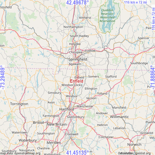
Enfield GPS coordinates[2]
41° 58' 34.356" North, 72° 35' 30.336" West
| Map corner | latitude | longitude |
|---|---|---|
| Upper-left | 42.49678°, | -73.29489° |
| Center: | 41.97621°, | -72.59176° |
| Lower-right: | 41.45135°, | -71.88864° |
| Map W x H: | 116.2×116.2 km | = 72.2×72.2mi |
| max Lat: | 71.29058° ⇑24.5% North |
| Enfield: | 41.97621° |
| min Lat: | ⇓75.5% South 19.06759° |
| min Long | Enfield | max Long |
| -171.73463° | -72.59176° | -66.98998° |
| W 94.7%⇐ | ⇒5.3% E |
Elevation
Elevation of Enfield is 53 m = 174 ft, and this is 241.8 m = 793 ft below average elevation for this country.
| Max E: |
3189 m = 10463 ft | 78.6% |
| Avg. | 294.8 m = 967 ft | |
| Enfield | 53 m = 174 ft | |
Min E: |
-60 m = -197 ft | 21.4% |
See also: Enfield elevation on elevation.city.
Geographical zone
Enfield is located in North temperate zone (between Tropic of Cancer and the Arctic Circle). Distance of this Northern Tropic circle is 2061.4 km =1280.9 mi to South.| Distance of | km | miles | from Enfield |
|---|---|---|---|
| North Pole | 5339.7 | 3317.9 | to North |
| Arctic Circle | 2733.9 | 1698.8 | to North |
| Tropic Cancer | 2061.4 | 1280.9 | to South |
| Equator | 4667.3 | 2900.1 | to South |


Nearby cities:
15 places around Enfield: (largest is in red/bold)
• Agawam
10.6 km =6.6 mi,  349°
349°
• East Longmeadow
11.8 km =7.3 mi,  33°
33°
• East Windsor
8.1 km =5 mi,  151°
151°
• Ellington
12.9 km =8 mi,  128°
128°
• Hazardville
4.1 km =2.5 mi,  72°
72°
• Longmeadow
8.2 km =5.1 mi,  5°
5°
• Sherwood Manor
4.7 km =2.9 mi, 28°
• Somers
12.1 km =7.5 mi,  85°
85°
• Southwood Acres
2.3 km =1.4 mi, 132°
• Springfield
13.9 km =8.6 mi,  0°
0°
• Suffield Depot
4.8 km =3 mi,  276°
276°
• Thompsonville
2.4 km =1.5 mi, 345°
• West Springfield
14.7 km =9.1 mi, 350°
• Windsor
14.4 km =8.9 mi,  197°
197°
• Windsor Locks
6 km =3.7 mi,  209°
209°
Sources, notices
• [Note1] Compared only with cities in United States existing in our database
• [Src1] Map data: © OpenStreetMap contributors (CC-BY-SA)
• [Src2] Other city data from geonames.org with taken over terms of usage.
• [Src3] Geographical zone / Annual Mean Temperature by Robert A. Rohde @ Wikipedia
