Killingly Center geodata
Killingly Center (Connecticut) is a populated place; located in United States in America/New_York (GMT-4) time zone. With population of 17,282 people, there are 2870 cities with bigger population in this country. Compared to other cities in United States, 74.2% of cities are located further ↓South; 96% of cities are located further ←West and 69.4% of cities have higher elevation than Killingly Center. Note1


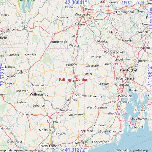
Killingly Center GPS coordinates[2]
41° 50' 19.356" North, 71° 52' 9.264" West
| Map corner | latitude | longitude |
|---|---|---|
| Upper-left | 42.36041°, | -72.57237° |
| Center: | 41.83871°, | -71.86924° |
| Lower-right: | 41.31272°, | -71.16612° |
| Map W x H: | 116.5×116.5 km | = 72.4×72.4mi |
| max Lat: | 71.29058° ⇑25.8% North |
| Killingly Center: | 41.83871° |
| min Lat: | ⇓74.2% South 19.06759° |
| min Long | Killingly Cente | max Long |
| -171.73463° | -71.86924° | -66.98998° |
| W 96%⇐ | ⇒4% E |
Elevation
Elevation of Killingly Center is 104 m = 341 ft, and this is 190.8 m = 626 ft below average elevation for this country.
| Max E: |
3189 m = 10463 ft | 69.4% |
| Avg. | 294.8 m = 967 ft | |
| Killingly Center | 104 m = 341 ft | |
Min E: |
-60 m = -197 ft | 30.6% |
See also: United States elevation on elevation.city.
Geographical zone
Killingly Center is located in North temperate zone (between Tropic of Cancer and the Arctic Circle). Distance of this Northern Tropic circle is 2046.1 km =1271.4 mi to South.| Distance of | km | miles | from Killingly Center |
|---|---|---|---|
| North Pole | 5355 | 3327.4 | to North |
| Arctic Circle | 2749.1 | 1708.2 | to North |
| Tropic Cancer | 2046.1 | 1271.4 | to South |
| Equator | 4652 | 2890.6 | to South |


Nearby cities:
15 places around Killingly Center: (largest is in red/bold)
• Brooklyn
8.7 km =5.4 mi,  229°
229°
• Chepachet
18.4 km =11.4 mi,  62°
62°
• Danielson
4.2 km =2.6 mi,  198°
198°
• East Brooklyn
5.2 km =3.2 mi,  206°
206°
• Foster
9.4 km =5.8 mi,  79°
79°
• Greene
19.3 km =12 mi,  148°
148°
• Moosup
14 km =8.7 mi,  183°
183°
• North Grosvenor Dale
16.5 km =10.3 mi,  351°
351°
• Pascoag
19 km =11.8 mi,  46°
46°
• Plainfield
18.4 km =11.4 mi,  191°
191°
• Plainfield Village
18.6 km =11.6 mi, 194°
• Putnam
9.1 km =5.7 mi,  338°
338°
• South Woodstock
13.4 km =8.3 mi,  326°
326°
• Thompson
13.4 km =8.3 mi,  2°
2°
• Wauregan
11 km =6.8 mi, 197°
Sources, notices
• [Note1] Compared only with cities in United States existing in our database
• [Src1] Map data: © OpenStreetMap contributors (CC-BY-SA)
• [Src2] Other city data from geonames.org with taken over terms of usage.
• [Src3] Geographical zone / Annual Mean Temperature by Robert A. Rohde @ Wikipedia
