Foster geodata
Foster (Rhode Island) is a populated place; located in United States in America/New_York (GMT-4) time zone. With population of 4,598 people, there are 7545 cities with bigger population in this country. Compared to other cities in United States, 74.4% of cities are located further ↓South; 96.1% of cities are located further ←West and 56.1% of cities have lower elevation than Foster. Note1
Administrative division(s):
- Level 1: Rhode Island
- Level 2: Providence County
- Level 3: Town of Foster


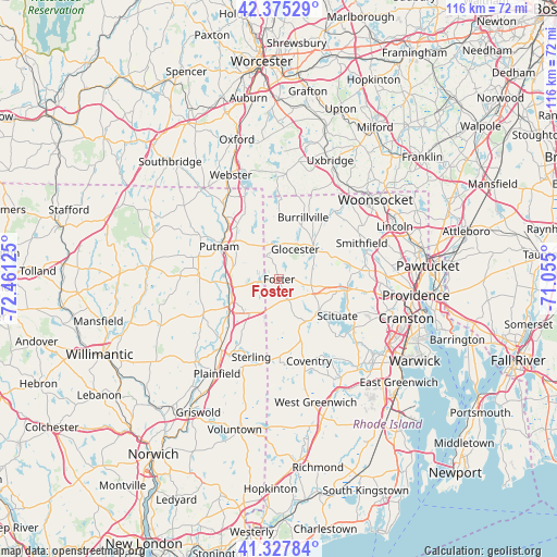
Foster GPS coordinates[2]
41° 51' 13.356" North, 71° 45' 29.232" West
| Map corner | latitude | longitude |
|---|---|---|
| Upper-left | 42.37529°, | -72.46125° |
| Center: | 41.85371°, | -71.75812° |
| Lower-right: | 41.32784°, | -71.055° |
| Map W x H: | 116.5×116.5 km | = 72.4×72.4mi |
| max Lat: | 71.29058° ⇑25.6% North |
| Foster: | 41.85371° |
| min Lat: | ⇓74.4% South 19.06759° |
| min Long | Foster | max Long |
| -171.73463° | -71.75812° | -66.98998° |
| W 96.1%⇐ | ⇒3.9% E |
Elevation
Elevation of Foster is 223 m = 732 ft, and this is 71.8 m = 236 ft below average elevation for this country.
| Max E: |
3189 m = 10463 ft | 43.9% |
| Avg. | 294.8 m = 967 ft | |
| Foster | 223 m = 732 ft | |
Min E: |
-60 m = -197 ft | 56.1% |
See also: United States elevation on elevation.city.
Geographical zone
Foster is located in North temperate zone (between Tropic of Cancer and the Arctic Circle). Distance of this Northern Tropic circle is 2047.8 km =1272.4 mi to South.| Distance of | km | miles | from Foster |
|---|---|---|---|
| North Pole | 5353.4 | 3326.4 | to North |
| Arctic Circle | 2747.5 | 1707.2 | to North |
| Tropic Cancer | 2047.8 | 1272.4 | to South |
| Equator | 4653.7 | 2891.7 | to South |


Nearby cities:
15 places around Foster: (largest is in red/bold)
• Brooklyn
17.5 km =10.9 mi,  245°
245°
• Chepachet
9.9 km =6.2 mi,  46°
46°
• Coventry
18.2 km =11.3 mi,  159°
159°
• Danielson
12 km =7.5 mi,  241°
241°
• East Brooklyn
13.2 km =8.2 mi, 241°
• Greene
18.1 km =11.2 mi,  176°
176°
• Greenville
17.2 km =10.7 mi,  83°
83°
• Harmony
13.9 km =8.6 mi,  74°
74°
• Harrisville
14.2 km =8.8 mi,  29°
29°
• Killingly Center
9.4 km =5.8 mi,  259°
259°
• North Scituate
14.4 km =8.9 mi,  99°
99°
• Pascoag
12.2 km =7.6 mi,  22°
22°
• Putnam
14.2 km =8.8 mi,  298°
298°
• Thompson
14.5 km =9 mi,  323°
323°
• Wauregan
17.5 km =10.9 mi,  225°
225°
Sources, notices
• [Note1] Compared only with cities in United States existing in our database
• [Src1] Map data: © OpenStreetMap contributors (CC-BY-SA)
• [Src2] Other city data from geonames.org with taken over terms of usage.
• [Src3] Geographical zone / Annual Mean Temperature by Robert A. Rohde @ Wikipedia
