Stamford geodata
Stamford (Connecticut) is a populated place; located in United States in America/New_York (GMT-4) time zone. With population of 128,874 people, there are 240 cities with bigger population in this country. Compared to other cities in United States, 66.5% of cities are located further ↓South; 92.7% of cities are located further ←West and 90% of cities have higher elevation than Stamford. Note1
Administrative division(s):
- Level 1: Connecticut
- Level 2: Fairfield County
- Level 3: Town of Stamford


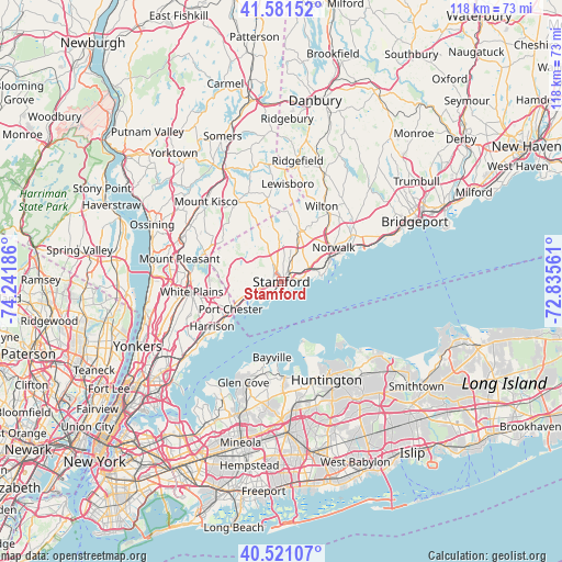
Stamford GPS coordinates[2]
41° 3' 12.348" North, 73° 32' 19.428" West
| Map corner | latitude | longitude |
|---|---|---|
| Upper-left | 41.58152°, | -74.24186° |
| Center: | 41.05343°, | -73.53873° |
| Lower-right: | 40.52107°, | -72.83561° |
| Map W x H: | 117.9×117.9 km | = 73.3×73.3mi |
| max Lat: | 71.29058° ⇑33.5% North |
| Stamford: | 41.05343° |
| min Lat: | ⇓66.5% South 19.06759° |
| min Long | Stamford | max Long |
| -171.73463° | -73.53873° | -66.98998° |
| W 92.7%⇐ | ⇒7.3% E |
Elevation
Elevation of Stamford is 16 m = 52 ft, and this is 278.8 m = 915 ft below average elevation for this country.
| Max E: |
3189 m = 10463 ft | 90% |
| Avg. | 294.8 m = 967 ft | |
| Stamford | 16 m = 52 ft | |
Min E: |
-60 m = -197 ft | 10% |
See also: Stamford elevation on elevation.city.
Geographical zone
Stamford is located in North temperate zone (between Tropic of Cancer and the Arctic Circle). Distance of this Northern Tropic circle is 1958.8 km =1217.1 mi to South.| Distance of | km | miles | from Stamford |
|---|---|---|---|
| North Pole | 5442.3 | 3381.7 | to North |
| Arctic Circle | 2836.5 | 1762.5 | to North |
| Tropic Cancer | 1958.8 | 1217.1 | to South |
| Equator | 4564.7 | 2836.4 | to South |


Nearby cities:
15 places around Stamford: (largest is in red/bold)
• Byram
11.1 km =6.9 mi,  240°
240°
• Cos Cob
5.6 km =3.5 mi,  246°
246°
• Darien
6.5 km =4 mi,  64°
64°
• East Norwalk
13.1 km =8.1 mi, 63°
• Glenville
10.4 km =6.5 mi,  258°
258°
• Greenwich
8.1 km =5 mi, 248°
• New Canaan
11 km =6.8 mi,  19°
19°
• North Stamford
9.4 km =5.8 mi,  357°
357°
• Norwalk
13.1 km =8.1 mi, 56°
• Old Greenwich
4 km =2.5 mi,  212°
212°
• Pemberwick
10.7 km =6.6 mi, 253°
• Port Chester
12.1 km =7.5 mi, 241°
• Riverside
4 km =2.5 mi, 236°
• Rye
14.6 km =9.1 mi, 236°
• Rye Brook
12.7 km =7.9 mi, 252°
Sources, notices
• [Note1] Compared only with cities in United States existing in our database
• [Src1] Map data: © OpenStreetMap contributors (CC-BY-SA)
• [Src2] Other city data from geonames.org with taken over terms of usage.
• [Src3] Geographical zone / Annual Mean Temperature by Robert A. Rohde @ Wikipedia
